


Jöhstadt to Steinbach through the Preßnitz valley
Experience romantic paths, well-kept rest stops and historical witnesses from times long past on your hike from Jöhstadt to Steinbach through the Schwarzwasser - Preßnitz valley. The podcast episode of...
Experience romantic paths, well-kept rest stops and historical witnesses from times long past on your hike from Jöhstadt to Steinbach through the Schwarzwasser - Preßnitz valley. The podcast episode of Unterwegs im Sachsenland gives you a good impression of the region:
https://www.unterwegs-im-sachsenland.de/secondradio/summary/stage/Unterwegs-im-Sachsenland

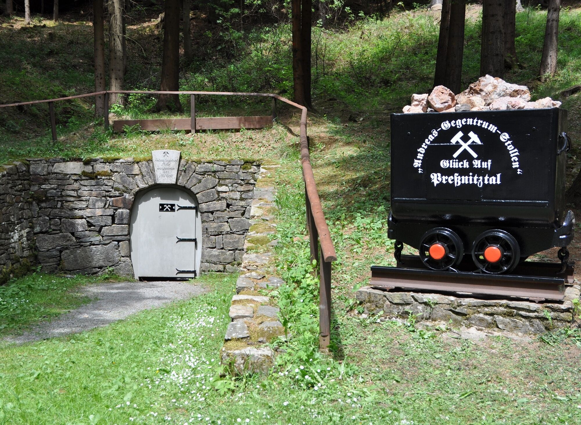
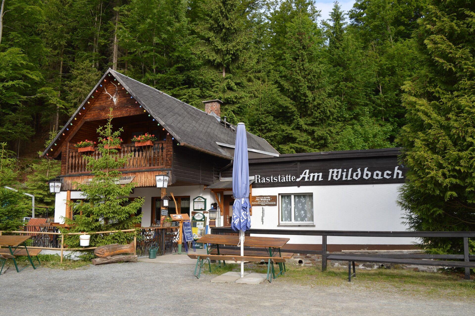
From the bus shelter we walk in the direction of "Bistro am Markt" where a small alley on the left leads us down to the sports field, which we leave on the left and continue down to Gründelstraße. Now keep left and walk to the edge of the forest. At the forest playground, we walk half right down into the valley to Schwarzwasser and enjoy the beautiful view from the "Alpine race track" to the ski hut in Schlössel. Now we continue down to the ridge path. The valley path meanders along the Schwarzwasser valley past a small idyllic rest area, further downstream after approx. 1 km there is a refuge on the left with seating for a hearty snack. We continue along the valley path, which is also the ridge path, to Schmalzgrube. Now we turn left and walk along the main road towards Steinbach for about 200 meters. Now turn left and walk along the Floßzechenweg in the direction of Andreas-Gegentrum-Stolln, then descend steeply to the half-right and walk along the Preßnitz stream again. Cross Grumbacher Straße and continue in the direction of Stolln. There is a nice rest area at the Andreas-Gegentrum-Stolln. Now we continue to the "Am Wildbach" rest stop, which is on the left-hand side, and tackle the last stage to Steinbach station. From Steinbach station, we have the option of returning to Jöhstadt on days when the Preßnitz Valley Railway is running.
Da
Da
Hiking gear - shoes, possibly rainwear, rucksack, provisions
Digital hiking pin
View the timetable for the Preßnitz Valley Railway
https://www.pressnitztalbahn.de/fahrplan-naechster-fahrtag
Digital hiking pin:
The hike is part of the digital hiking pin "For train enthusiasts". Download the SummitLynx app, activate your cell phone GPS and log in at check-in points worth seeing. These will take you on a total of 10 tours into the world of viaducts, railroad stations and fascinating museums on the subject.
The special thing about our digital hiking pins is that you can create your own personal tour book with pictures, texts and locations.
Priljubljeni izleti v okolici
-
4.7
Schlettau circular hiking trail "On the steps of Ottomar Zahm"
srednjaPohodništvo 11.0 km -
5.0
Rocky idyll and ridge view (Wolkenstein)
srednjaPohodništvo 15.2 km -
5.0
Katzenstein - Schwarzwassertal - Katzenstein
srednjaPohodništvo 15.5 km -
5.0
Alpine hiking trail - town of Wolkenstein/Warmbad (Boundless. Wild romantic nature experiences)
srednjaPohodništvo 10.1 km -
4.5
TK 9 - Wiesaer Höhenweg
srednjaPohodništvo 9.46 km -
RR ERZ T17 From the Fichtelberg, across the Zschopau valley to the Markersbach pumped storage plant
srednjaKolesarjenje 61.5 km -
Hike into soup country
srednjaPohodništvo 8.13 km -
5.0
Wiesenbad spa circular hiking trail
Pohodništvo 16.2 km -
5.0
Route of the 15th Erzgebirge Song Route from August 17, 2025
srednjaPohodništvo 16.9 km -
Schlettau circular hiking trail "Up to the Liebenstein"
srednjaPohodništvo 15.0 km

Pohodništvo in sledenje


Ne zamudite ponudb in navdiha za naslednje počitnice
Vaš e-poštni naslov je bil dodan na poštni seznam.