Navigacija po spletni strani
Pridobite to turo v svoj mobilni telefon
Zemljevid
Cyclosport route 9 - The wall of Péguère

težko
Cestno kolo
69.66 km
Skenirajte kodo QR in začnite navigacijo v aplikaciji bergfex.
QR Code
Pohodništvo in sledenje

Cyclosport route 9 - The wall of Péguère
Razdalja
69.7 km
Trajanje
04:30 h
Ascent
1,436 hm
Morska gladina
386 - 1,376 m
Prenos skladbe
Zemljevid
Cyclosport route 9 - The wall of Péguère
težko
Cestno kolo
69.66 km

Initially climbed during the Tour de France in 2012, it deserves its nickname "the wall." Up there, take a break and admire one of the most beautiful panoramas of the Pyrenees before returning to Foix...

Opis

Initially climbed during the Tour de France in 2012, it deserves its nickname "the wall." Up there, take a break and admire one of the most beautiful panoramas of the Pyrenees before returning to Foix via the Col des Marrous and finishing through the bucolic Barguillère valley.

Be aware that part of the route is closed during the winter period.

Pot
Foix
(388 m)
Mesto
0.0 km
Église Notre-Dame-de-l'Assomption
(434 m)
Kraj čaščenja
4.6 km
Peyregat
(499 m)
Soseska
10.3 km
Église Saint-Nicolas
(537 m)
Kraj čaščenja
18.1 km
Église Saint-Blaise
(923 m)
Kraj čaščenja
27.4 km
Mourouet
(1,009 m)
Poravnava
37.0 km
Église Saint-Joseph
(679 m)
Kraj čaščenja
56.5 km
Pot
Zemljevid
Cyclosport route 9 - The wall of Péguère
težko
Cestno kolo
69.66 km
Foix
(388 m)
Mesto
0.0 km
Ferrières-sur-Ariège
(407 m)
Vas
2.8 km
Église Notre-Dame-de-l'Assomption
(434 m)
Kraj čaščenja
4.6 km
Prayols
(429 m)
Vas
4.7 km
Ginabat
(472 m)
Poravnava
6.8 km
Amplaing
(501 m)
Poravnava
10.1 km
Jardy
(506 m)
Soseska
10.2 km
Peyregat
(499 m)
Soseska
10.3 km
Bompas
(464 m)
Vas
12.5 km
Arignac
(507 m)
Vas
12.8 km
Tarascon-sur-Ariège
(473 m)
Vas
15.7 km
Les 3 Buffets
(484 m)
Restavracija
16.6 km
Cagnac
(487 m)
Poravnava
16.6 km
La Forge
(514 m)
Soseska
17.8 km
Église Saint-Nicolas
(537 m)
Kraj čaščenja
18.1 km
Surba
(551 m)
Vas
18.2 km
Bédeilhac
(643 m)
Vas
20.3 km
Auberge de la grotte Chez Peïo
(641 m)
Restavracija
20.3 km
Aynat
(658 m)
Vas
20.6 km
Le Châlet
(634 m)
Restavracija
21.8 km
Saurat
(672 m)
Vas
22.9 km
Église Sainte-Madeleine
(677 m)
Kraj čaščenja
23.0 km
La Ruzole du Bas
(862 m)
Poravnava
26.5 km
La Ruzole du Haut
(883 m)
Poravnava
26.6 km
Loumet
(939 m)
Poravnava
27.2 km
Église Saint-Blaise
(923 m)
Kraj čaščenja
27.4 km
Auberge de la Sapinière
(1,248 m)
Restavracija
32.8 km
Fontaine de Guindoulet
(1,247 m)
Vir:
33.2 km
Mourouet
(1,009 m)
Poravnava
37.0 km
Jacoy
(986 m)
Poravnava
38.1 km
Col des Marrous
(992 m)
Koridor/teren
51.3 km
Bourrel
(941 m)
Poravnava
52.1 km
Fierrioulet
(941 m)
Poravnava
52.8 km
Le Bosc
(674 m)
Vas
54.0 km
Madranque
(898 m)
Poravnava
54.1 km
Falquet
(736 m)
Poravnava
54.7 km
Peyroutéou
(718 m)
Poravnava
55.0 km
Burret
(675 m)
Vas
56.5 km
Église Saint-Joseph
(679 m)
Kraj čaščenja
56.5 km
La Mouline
(503 m)
Poravnava
60.9 km
Serres-sur-Arget
(540 m)
Vas
61.4 km
La Barguillère
(447 m)
Restavracija
64.9 km
Saint-Pierre-de-Rivière
(444 m)
Vas
65.0 km
La Rochelle
(427 m)
Poravnava
66.9 km
Ruffié
(422 m)
Poravnava
67.3 km
Moulinery
(394 m)
Poravnava
68.3 km
Foix
(388 m)
Mesto
69.4 km
Informacije o turneji

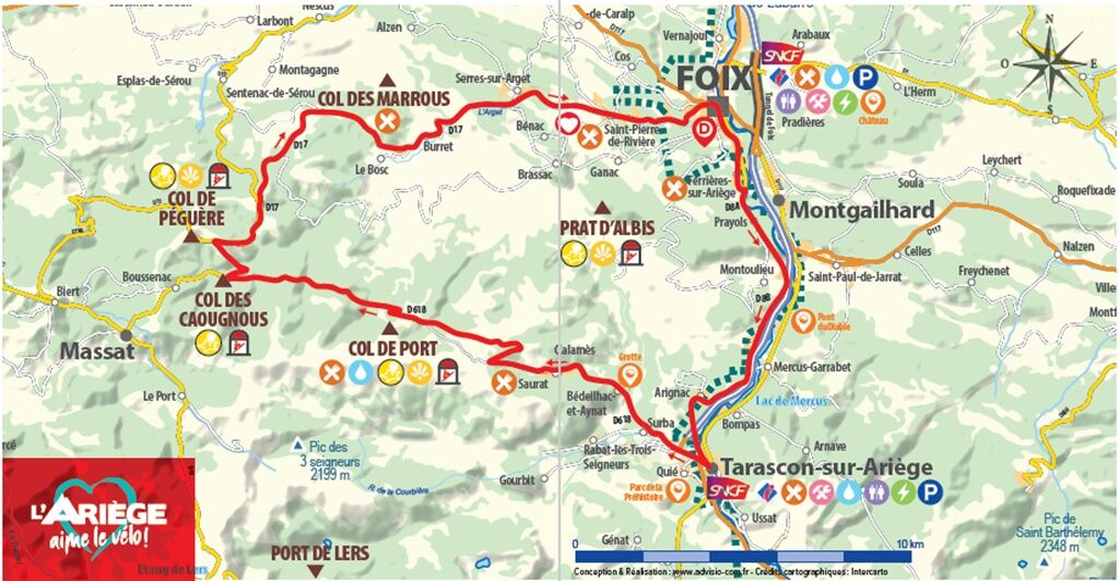
You follow the Ariège on the left bank up to the gates of Tarascon-sur-Ariège. A first climb towards the Col de Port before heading to the highest point: Péguère, where some sections reach a 16% gradient.

Tehnologija
n.a.
Stanje
5 / 6
Pokrajina
5 / 6
Izkušnje
5 / 6
Najboljši letni čas
Jan
Feb
Mar
Apr
Maj
Jun
Jul
Avg
Sep
Okt
Nov
Dec
Skupna turneja
Zemljevid
Cyclosport route 9 - The wall of Péguère
težko
Cestno kolo
69.66 km
Napaka
Zgodila se je napaka. Prosimo, poskusite znova.
Informacije o poti
Pot

1 - FROM FOIX TO TARASCON-SUR-ARIÈGE

Starting from the Foix Tourist Office, head towards Ferrières-sur-Ariège via the D8A. Continue on the D8B then cross Arignac to reach Tarascon-sur-Ariège.

2 - FROM TARASCON-SUR-ARIÈGE TO THE COL DE PÉGUÈRE

Arriving at the roundabout in Tarascon-sur-Ariège, take the first exit onto Route de Saurat then at the next roundabout continue straight towards Surba. Next, just continue on the D618 until reaching the Col de Port. At Boussenac, turn right onto the D17 to reach the Col de Péguère.

3 - FROM THE COL DE PÉGUÈRE TO FOIX

From the Col de Péguère, continue on the D17 towards Le Bosc. You will cross Saint-Pierre de Rivière before returning to Foix.

Varnostna navodila

Emergency number: 112

Dodatne informacije in nasveti
Dodatne informacije

To learn more about our destination, visit our website

Nasveti

Check inforoute09.fr before departure. Respect the proposed direction: descending the Col de Péguère is very dangerous.

Pohodništvo in sledenje

Pohodništvo in sledenje

Pohodništvo in sledenje
Zaradi več kot 550.000 predlogov izletov, podrobnih zemljevidov in intuitivnega načrtovanja poti je aplikacija obvezna oprema za vse ljubitelje narave.
bergfex