







Hike to Rifugio Balma from Forno di Coazze - Orsiera Rocciavrè Park
The Balma valley is characterized by its wild beauty, alternating gray and red rocky walls, due to the presence of iron, with grassy areas rich in high-altitude flowers and powerful water flows. The effects...
The Balma valley is characterized by its wild beauty, alternating gray and red rocky walls, due to the presence of iron, with grassy areas rich in high-altitude flowers and powerful water flows. The effects of Quaternary glaciations are evident from the presence of moraines, cirque lakes, and glacial damming found just above the refuge (Lower, Middle, and Upper Lake).
In autumn, it is possible to admire the explosion of colors gifted by the beech forests, also rich in the famous porcini mushrooms of the Upper Sangone Valley, and red slopes of rhododendrons and blueberries.
INFO: https://www.rifugiobalma.it/

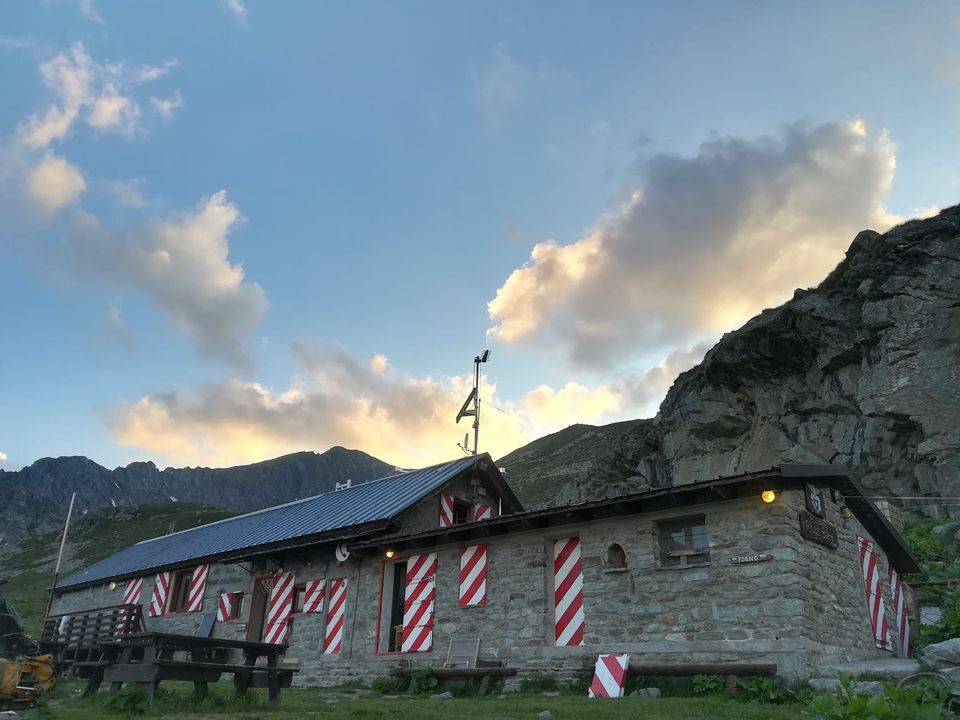

Start on foot from Case Agostino-Cara 'd Tajè (park before the gate of the Pian Neiretto ski resort even when it is open). The trail, indicated as 415a on Fraternali maps, climbs through a birch grove until it reaches the right bank of the Balma River in a few minutes. At this point, there are two options: either cross the stream via the “tibetan bridge” and ascend through the woods until reaching the path coming from Molé; or do not cross the stream and continue along the path indicated as “partisan trail” or “military trail,” crossing the river further upstream once out of the wooded area.
When the two trails reunite, continue always on the left bank near the stream, reaching a first fountain; the trail then climbs with switchbacks up to quota 1650, where it proceeds diagonally among the last birches and skirts a ridge from which the next section of the valley appears.
The trail alternates diagonal sections and short switchbacks, crossing some scree fields, then makes a final series of short zigzags before the ridge from which the refuge appears. After a few hundred meters, you will encounter a second fountain, the “Funtena du Roc,” and continue along a pleasant traverse that leads to the Balma Refuge.
For the descent, the same ascent route can be used with some possible variations, but always returning to Case Agostino.
INFO: https://www.rifugiobalma.it/
In summer, trekking equipment is recommended. In winter, consider snowshoes or crampons depending on snow conditions.
Check and assess the weather conditions, and in winter also the snow cover, before undertaking the hike.
I suggest planning an overnight stay at the refuge to climb one or more of the surrounding peaks.
Priljubljeni izleti v okolici
Avigliana Lakes - Easy route, ideal for families with children
svetlobaPohodništvo 9.25 km- 5.0
Unspoiled woods and ancient hamlets in Valsangone - Selvaggio Loop - Bagaggera
svetlobaPohodništvo 9.08 km PINEROLO Route to Monte Muretto
srednjaPohodništvo 2.12 kmFENESTRELLE MTB to Selleries Refuge
srednjaKolesarjenje 16.0 kmLe Strade dei Forti
težkoRomarska pot 227.2 km- 4.0
The Giro dell'Orsiera G.O. Trail Stage 1: Molè - Rifugio Balma
srednjaPohodništvo 4.52 km PINEROLO Trail "Ecomuseum of the Charcoal Piles"
srednjaPohodništvo 7.46 kmCUMIANA by MTB on the Amphitheater Path
srednjaMountainbike 32.4 km- 4.0
ROURE by MTB at Prato del Colle
srednjaKolesarjenje 7.82 km Le Strade dei Forti - stage 7 from Fenestrelle to Pian dell'Alpe
srednjaRomarska pot 11.5 km
Pohodništvo in sledenje


Ne zamudite ponudb in navdiha za naslednje počitnice
Vaš e-poštni naslov je bil dodan na poštni seznam.





