


Via Francigena for all | Ivrea- Viverone section
This stretch of the Via Francigena Morenico Canavesana starts from the center of Ivrea, passing by Lake San Michele and Lake Cascinette d’Ivrea, with its splendid panoramic point on the Serra, on Andrate and...
We start from the center of Ivrea, in Piazza Ferruccio Nazionale in front of the Town Hall: the surface is made of porphyry cubes and the area is partly a pedestrian area. The trail turns right onto a linear and direct path suitable for wheelchairs, then turns left entering the park of Piazza S. Francesco and then - protected from vehicles - into the side road of Corso Botta (there are no signs).We are in the park of Piazza S. Francesco. We turn left and cross Corso Botta. In the side road of Piazza Freguglia we come across a rest point for walkers where it is possible to stamp the Via Francigena credential.We travel along the whole of Corso d'Azeglio using the double cycle path: the sign indicates crossing the street, while the trail continues for dozens of meters and crosses further ahead.We are in Via Cascinette: on one side the sidewalk is quite large, on the other almost non-existent. We come across a busy roundabout where it is advisable to cross on the right. After the roundabout, continue on the left, with a wide sidewalk. We find another busy roundabout where there are more sidewalks. After leaving Ivrea, we find ourselves in via Monte della Guardia: the road has good asphalt and local traffic leads to the nearby villas. We take the fork on the right, still on decent asphalt, and then the one on the left (via Tinasse di Sopra), to find ourselves on a road with a mixed gravel and earth surface. Another fork on the left with a sign hidden by vegetation. Last fork: from the right you arrive from the Cascinette Cemetery where a stretch of path in the woods begins. Initially flat and, later, with passages on simple rocks where particular attention must be paid after heavy rains. Here we find a bench and a sign indicating the route.
With a wheelchair, or in the presence of mobility difficulties, you can take the flat variant of Via del Lago Campagna until you cross the original route of the second section and continue walking.
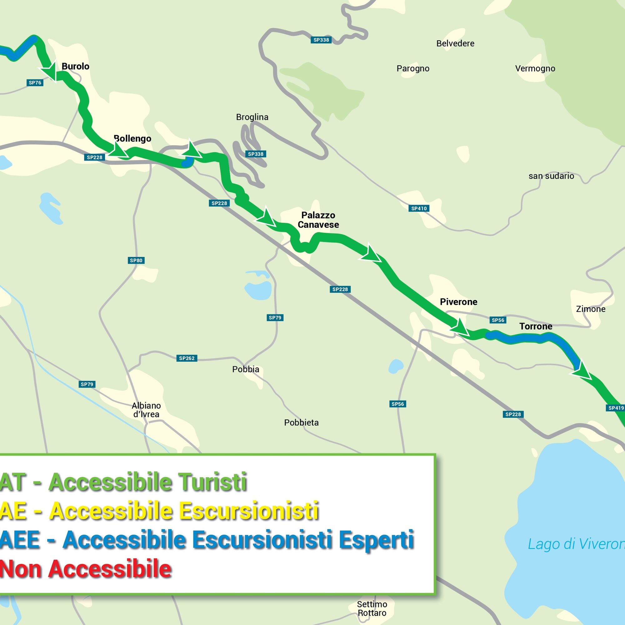
LAGO DI CAMPAGNA-BOLLENGO
The official start of this section is on a high point overlooking the lake: we are at the exit of the difficult terrain, a last step and then from the grassy meadow - after a roundabout - we walk on the asphalt. The road leads to the Cascinette cemetery and is therefore not very busy. From the outskirts we cross the Cascinette-Chiaverano provincial road, where city buses also pass. At the crossroads, on the right we leave the provincial road and enter a small road serving the last houses, where the asphalt ends; the road becomes a natural surface and after rain it can have many puddles. From the woods with very tall trees we enter a humid area of ââââmareschi, then we cross large cultivated fields. The route then becomes asphalted until the end of the section, without side protections and heavy traffic. We continue to the left, as per the signs, slightly uphill at times with protections, entering another busy road where there is a very narrow sidewalk. On the left, the asphalt road connects the municipalities of Burolo and Bollengo. Near the Burolo cemetery, we find a rest area with a fountain. We continue on another fork to the left and soon enter the municipality of Bollengo, finding a small sidewalk at times and ending the stretch behind the church of San Rocco.
BOLLENGO-PALAZZO CANAVESE
We continue on the asphalt road in the center of Bollengo (the sidewalk is narrow and there are numerous driveways). When leaving Bollengo, there is no more sidewalk and after the fork, we continue on the narrow asphalt road and then turn onto a natural path uphill (possibility of parking for 2
PALAZZO CANAVESE-PIVERONE
From the central street of Palazzo, with a sign and regular asphalt, the route bends to the left: we find stone steps, a handrail on the walls and then a path with cobblestones. From here on we will always walk on asphalt. At the crossroads and the large clearing, the Via Francigena sign now in poor condition and the last houses of Palazzo Canavese. The provincial road to Piverone, quite busy, has an uphill stretch with many cars and bicycles at high speed in the opposite direction; we then pass next to the church of San Genesio in Mediavilla: the stretch is slightly uphill with lateral protections and signs. Here we come across a crossroads with another secondary road, signs for local hiking trails and a sign for the next rest point at the entrance to Piverone, where the road surface with porphyry cubes begins. In the center of Piverone, the crossing of the provincial road to Biella is heavily trafficked. In the square we find the signs for the route.
PIVERONE-VIVERONE
Leaving the town of Piverone, crossroads with an internal road and subsequent 2 forks still on asphalt, although not regular at times due to recent work. Once the asphalt section ends, a natural surface path begins on forest roads and you come across a rest point for walkers with a small house containing books.After the crossroads with another path, a signpost indicates the direction: we are near the ruined church "Gesiun", where we pass from a short stretch on asphalt to a natural gravel surface. At the fork on the right (without signs) we pass to a mixed surface of earth, grass and gravel and then to a carriageable stretch first on natural surface and then asphalt, up to the entrance to Viverone.
Da
Da
AT Accessible Tourists (green line)
Paths on cart tracks, dirt roads, grassy sheep tracks. They are characterized by modest slopes (less than 8%), width (greater than 1.5 m), limited differences in height (less than 150 m), length under 3 km. They generally have a homogeneous and smooth surface, without artificial or natural steps, without exposed points or tight curves that can make maneuvers difficult.
Notes for the Off-Road Aid Crew/Drivers: although it is possible to overcome small slopes independently with a self-propelled wheelchair, for safety it is never advisable to use the paths alone.
AE Accessible Hikers (Yellow line)
Paths on obvious paths and paved mule tracks. They are characterized by moderate slopes (under 16%), width between one and one and a half meters, height differences under 300 meters, length from 3 to 6 km, uneven ground, few and/or modest artificial or natural steps that can be easily overcome by an off-road aid (joelette), absence of significant obstacles, absence of exposed points and/or tight curves that can make maneuvers difficult.
Notes for the Off-Road Aid Crew/Drivers: regardless of the length of the route, it is necessary to take into account the time necessary to complete the excursion in relation to the critical points.Accessible
AEE Expert Hikers (blue line)
Routes on mule tracks and paths with traces of passages on varied terrain. They are characterized by some sections with slopes even greater than 16%, width less than 1 meter, height differences greater than 300 meters, length greater than 6 km, uneven ground that leads to forced passages, natural or artificial steps over 10 cm, significant obstacles, exposed points and/or tight curves.
Notes for the Off-Road Aid Crew/Drivers: the route requires technical skills, experience and adequate equipment. Regardless of the length of the route, it is necessary to take into account the time necessary to complete the excursion in relation to the critical points.
BY CAR
From Turin: A5 Turin-Aosta motorway, Ivrea exit tollgate. From Milan: A4 Milan-Turin motorway, A4-A5 Santhià-Ivrea junction, A5 towards Aosta, Ivrea exit tollgate. From Aosta: A5 Aosta-Turin motorway, Ivrea exit tollgate. From Genoa: A26 Genoa-Gravellona motorway, A26dir Alessandria-Santhià, A4-A5 Santhià-Ivrea junction, A5 towards Aosta, Ivrea exit tollgate.
Ivrea is connected by the Turin-Aosta railway line. To reach Ivrea from Aosta: Aosta-Turin line, Ivrea station From Milan: Milan-Turin line, change at Chivasso and Turin-Aosta line, stop at Ivrea station From Alessandria: Genoa-Turin line with change at Turin Porta Nuova; Turin-Aosta line and stop at Ivrea station From Turin: Turin-Aosta line and stop at Ivrea station You can take the train towards Ivrea from both Turin Porta Nuova and Turin Porta Susa stations to reach Ivrea station after about an hour.
Trains for disabled people
Trains equipped for disabled people are marked with the appropriate logo. For more information, see the “Sala Blu” section on the Trenitalia website.
BUS
Ivrea is mainly served by public transport by Sadem, which covers the entire area of ââNorth West Italy, and by Gruppo Torinese Trasporti (GTT), which manages urban and suburban transport in the City of Turin and in 25 other municipalities in the belt.
Buses for disabled people Sadem
The service is only active to reach Ivrea from Aosta. It is necessary to report well in advance the need for a bus with a lift to the number 0125 807010 of Pont St. Martin.
GTT
For information: Toll-free number 800 019152
Multisensory signs: in each Municipality along the route, the panels present content reproduced in relief that can be explored by those with visual and hearing disabilities, with combinations of visual, auditory and tactile information.
Open-door churches: the collaboration with the Ecclesiastical Region project allows independent visits, 365 days a year, to ecclesiastical cultural assets through the free app of the same name, with the opening to the public of 20 new locations along the Via Francigena now accessible to people with sensory and cognitive disabilities through multisensory audio and video panels in sign language, videos in LIS (Italian sign language), cards in augmentative alternative communication narrating the sites and the works kept inside.
Along the route and nearby you can visit in the following ways:
Cathedral, Crypt and Taddeo Mc Carthy Tomb in Ivrea Church of San Nicola da Tolentino in IvreaSaints Peter and Paul in BollengoChurch of San Rocco in Montalto DoraSanto Stefano di Sessano in Chiaverano Sant'Eusebio al Masere in Scarmagno Santa Maria di Spinerano in San Carlo Canavese Sant'Evasio in OglianicoSan Pietro in Issiglio Santa Maria Maddalena in BuroloIvrea: the city of Adriano Olivetti and his pioneering industrial and socio-cultural project, of which today you can visit the urban and architectural complex composed of 27 buildings designed by the most famous Italian architects and urban planners of the twentieth century, which since 2018 has been a UNESCO World Heritage Site Industrial City of the Twentieth Century. Worthy of note is the important Canoe Stadium on the Dora Baltea, home to training and international competitions.
Borgofranco d’Ivrea is the town – symbol of the “Balmetti”, characteristic natural cellars with a rectangular plan, with one or two floors above ground, dug into the morainic rock in the Mombarone massif, mainly used for the conservation of wine and cheese.
Bollengo: bell tower of San Martino (11th century), known by locals as the "Ciucarun", a stop recognized by wayfarers who travel the stretch of the Via Francigena eporediese est. Romanesque church of Saints Peter and Paul (equipped with multi-sensory panels and a rest area as per the “Via Francigena for all” project, it is part of the “Open Door Churches” circuit).
In Palazzo Canavese, the Torrione, the only surviving element of the ancient feudal castle.
Piverone is the village “of the 5 towers” ââ(Cortina Tower, San Pietro Tower, North-East Tower, North-West Tower and Porta Campanaria or Clock Tower). Just outside the center, at the crossroads of two country roads, among vineyards and cultivated fields, stand the remains of the "Gesiun", the original Romanesque church of S. Pietro di Sugliaco (13th century).
Lake Viverone: in addition to bathing activities and water sports, the lake hosts a few meters below the water level in an area of ââmarshes, meadows and poplars, the remains of about 5 thousand piles driven into the ground that supported the structures of a very ancient large pile-dwelling village dating back to the Bronze Age. Included in the system of "Prehistoric Pile-Dwelling Sites of the Alpine Arc", the archaeological site of Viverone in 2011 became part of the list of "World Heritage" sites protected by UNESCO. https://www.atl.biella.it/en/vedere-dettaglio/-/d/palafitte-lago-di-viverone
The Royal Road of Turin Wines promotes and protects the local wine heritage, with DOCG labels such as Erbaluce di Caluso and the red Carema DOC (to be tasted at the Regional Wine Shop of the Province of Caluso).
Priljubljeni izleti v okolici
-
SETTIMO VITTONE Colma di Mombarone from Trovinasse
srednjaPohodništvo 3.92 km -
VALCHIUSELLA Lakes of Alice Superiore and Meugliano
svetlobaPohodništvo 7.99 km -
3.0
Via Francigena Etappe 5
srednjaPohodništvo 36.7 km -
MONTALTO DORA Terre Ballerine - In search of Lake Coniglio
svetlobaPohodništvo 5.35 km -
Chiaverano - Church of Santo Stefano di Sessano
srednjaMountainbike 27.4 km -
CHIVASSO Multi-stage loop of the ancient Balteo Glacier
srednjaKolesarjenje na dolge razdalje 195.4 km -
Erratic boulders trail of Vialfré
svetlobaPohodništvo 7.15 km -
Ring of the Ancient Balteo Glacier - stage 4
srednjaKolesarjenje na dolge razdalje 51.0 km -
CHIAVERANO Loop on the Serra d'Ivrea
srednjaPohodništvo 14.5 km -
IVREA Ring Ivrea - Alice Superiore
srednjaKolesarjenje na dolge razdalje 35.0 km
Pohodništvo in sledenje


Ne zamudite ponudb in navdiha za naslednje počitnice
Vaš e-poštni naslov je bil dodan na poštni seznam.