


CHARBONNIERES HIKE
This thematic loop allows you to discover the life of the coalminers. Interpretation panels will help you find information along the way.

1
From the parking lot, turn left into the village onto Route d'Assas. Turn right towards the church. Reach the square and turn left into the narrow street, then right at the end. Continue for 150 m. At the crossroads, turn right for 200 m to a crossroads (calvary). Take the road (chemin du Mas-de-Greffier) on the left for 500 m to leave the village.
2
Just after a DFCI track on the left, leave the road by a track on the right, under the pines. Follow a field to the right and, a few metres further on, leave the main road to take the second path on the left. It winds through a wood and reaches a track; take this to the right.
3
Go straight on for about 200 m, then leave the track for a winding path on the left, through undergrowth. Reach a crossroads. Go left into the Mounié woods. Further on, reach an intersection; go right.
4
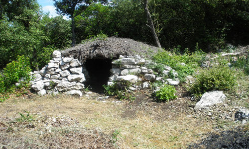
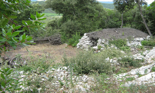
Option to take a short variation of the circuit (5.5 km, 2 h): on the left, pass a charcoal kiln (theme sign) and continue for 20 m to rejoin the main circuit. Continue uphill, passing a lapiaz (surface erosion of certain limestone rocks, presenting a series of deep grooves separated by sharp edges), then a charbonnière. Turn left and climb to an open area.
5
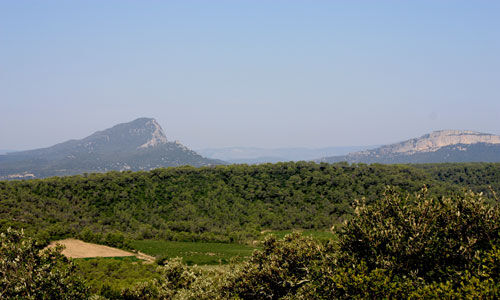
Access to a viewpoint (50 m): climb to the right (viewpoint over the plain, Pic Saint-Loup, Château de Montferrand, Plateau de l'Hortus), then retrace your steps. Descend the path (steep descent).
6
Continue downhill (leaving the variant on the left) until you reach a well-marked crossroads. Go straight ahead, then turn right. Pass a small kiln and turn right to reach a lime kiln.
7
Access to a charcoal kiln (200 m): go around the kiln to the left and, on the left, follow the path to the last charcoal kiln, then retrace your steps. Below the lime kiln, on the right, continue along the path which winds down through the garrigue to join the track. To the right, follow the same route back to the starting point.
PR Yellow
https://www.grandpicsaintloup-tourisme.fr/
Office de Tourisme du Grand Pic Saint-Loup
PDESI
Priljubljeni izleti v okolici
- 4,0
PIC SAINT LOUP HIKE
srednjaPohodništvo 2,64 km HIKING THE CASTRIES AQUEDUCT
svetlobaPohodništvo 11,4 km- 4,0
BOIS DE LÈQUE HIKE
svetlobaPohodništvo 9,34 km HIKE OF THE CHÂTEAU DE RESTINCLIERES
svetlobaPohodništvo 7,86 kmOENORANDO® BETWEEN GRÉS DE MONTPELLIER AND PIC SAINT-LOUP
srednjaPohodništvo 15,0 kmLA BOUCLE DE REGANHAT HIKE
svetlobaPohodništvo 4,33 kmHIKING THE TOUR DES VILLAGES DU PIC - GR® DE PAYS TOURS IN GRAND PIC SAINT-LOUP
srednjaPohodništvo 47,5 kmLOOP CYCLO N°18 - LA SOURCE DU LEZ
svetlobaKolesarjenje 13,9 kmWINE ROUTE IN THE SHADOW OF THE CHATEAU DE MONTFERRAND
Motorno kolo 49,8 kmOENORANDO® DES COTEAUX DE SAINT-CHRISTOL - FFRANDONNÉE® CERTIFIED
svetlobaPohodništvo 7,74 km
Pohodništvo in sledenje


Ne zamudite ponudb in navdiha za naslednje počitnice
Vaš e-poštni naslov je bil dodan na poštni seznam.