Le chemin des oiseaux
svetloba
Navigacija po spletni strani
Navigacija po spletni strani
Pridobite to turo v svoj mobilni telefon
Le chemin des oiseaux
svetloba
Pohodništvo
5,65
km
Skenirajte kodo QR in začnite navigacijo v aplikaciji bergfex.

Pohodništvo in sledenje


Le chemin des oiseaux
svetloba
Razdalja
5,65
km
Trajanje
02:30
h
Ascent
-
hm
Morska gladina
162 -
164
m
Prenos skladbe
Le chemin des oiseaux
svetloba
Pohodništvo
5,65
km
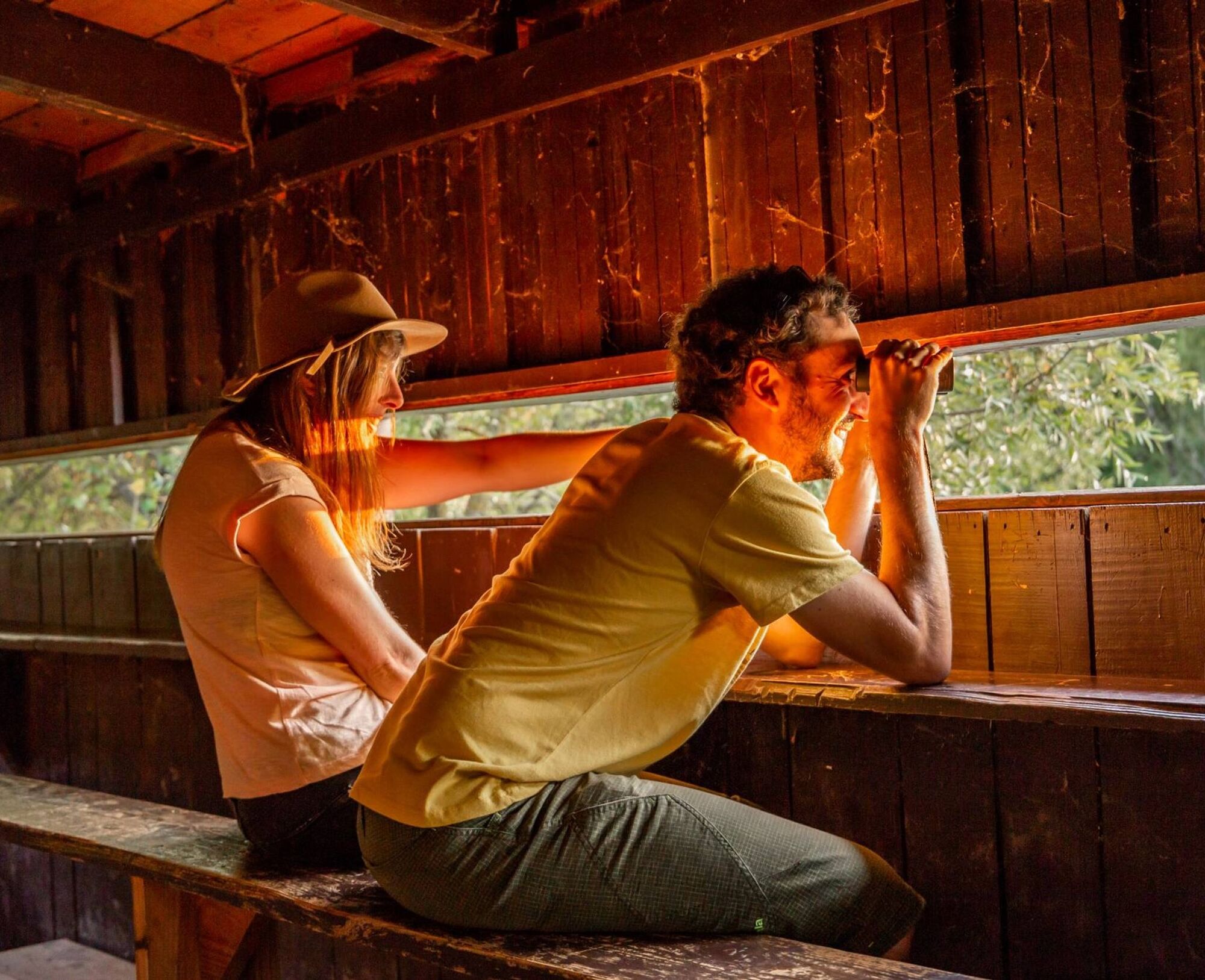
Observe without being seen
More than 200 species of birds can be observed in the regional nature reserve (RNR)! However, the ponds, fed by the Agout water table, were not intended to accommodate this heronry,...
Opis
Observe without being seen
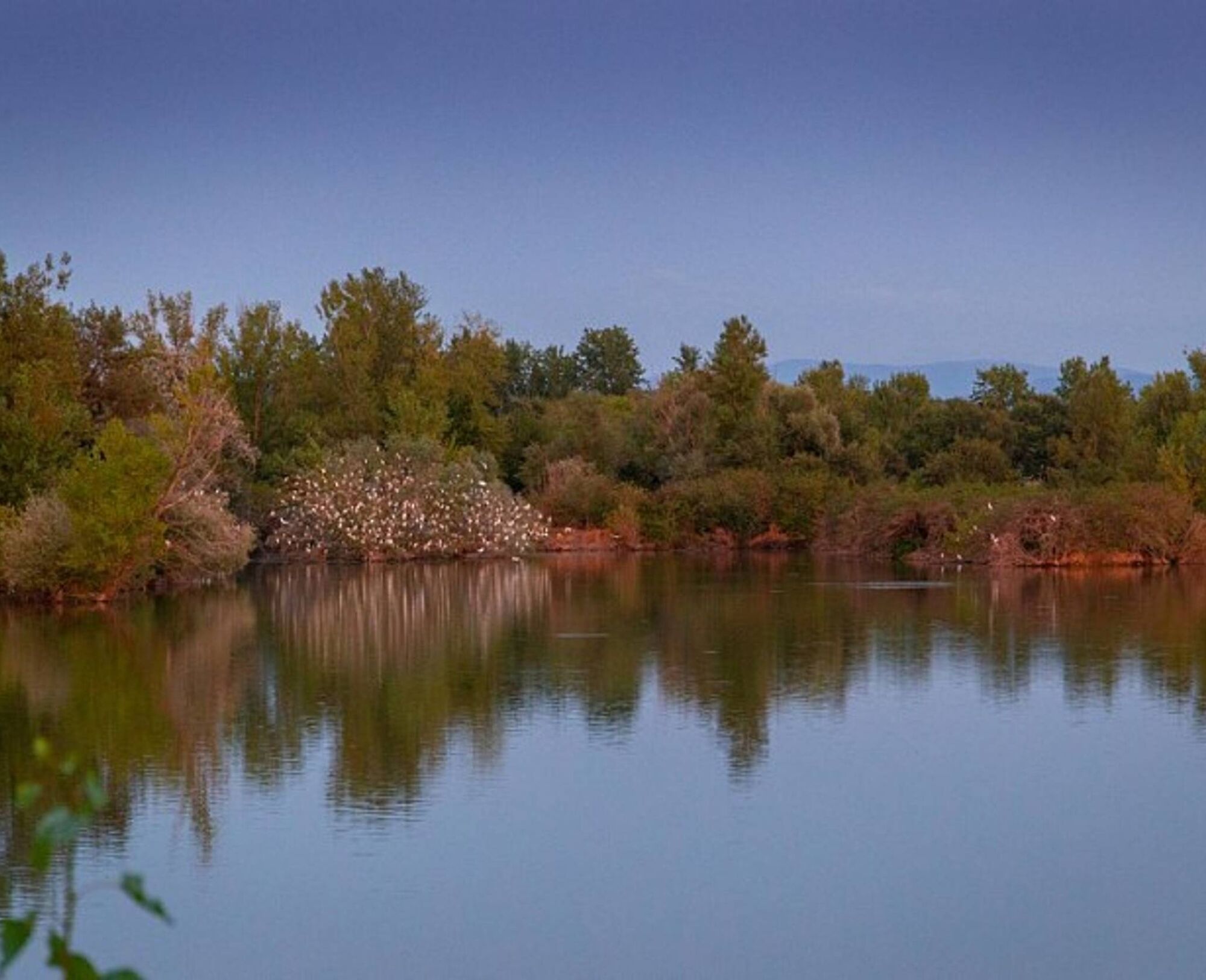
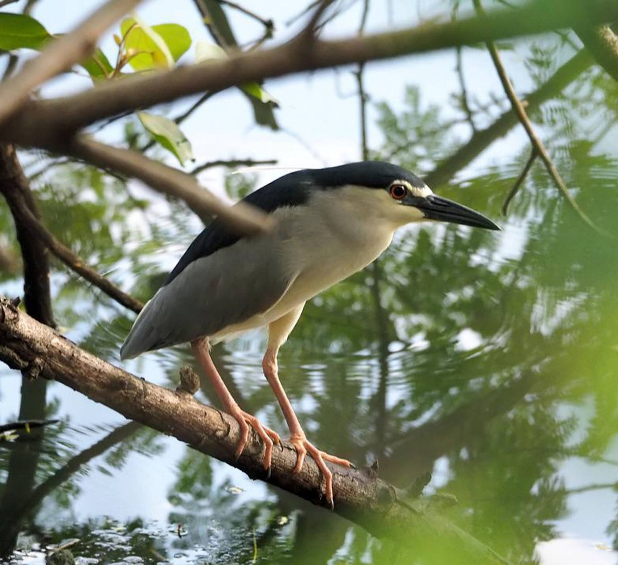
More than 200 species of birds can be observed in the regional nature reserve (RNR)! However, the ponds, fed by the Agout water table, were not intended to accommodate this heronry, one of the largest in Occitania… The materials extracted from the ponds were intended for the construction of the railway line linking Rodez to Castelnaudary. Since the 1970s, the tranquility of the bodies of water has attracted large numbers of herons. From then on, naturalists quickly understood the importance of conserving such an “ornithological spot”. Today, the bird trail allows you to go around the reserve without disturbing its occupants, with observatories judiciously marking its route. The walker can then observe grey herons, great crested grebes, black kites and many other species without being seen... Be careful, however, to remain discreet and patient: here, lenses and binoculars are essential.
More than 200 species of birds can be observed in the regional nature reserve (RNR)! However, the ponds, fed by the Agout water table, were not intended to accommodate this heronry, one of the largest in Occitania… The materials extracted from the ponds were intended for the construction of the railway line linking Rodez to Castelnaudary. Since the 1970s, the tranquility of the bodies of water has attracted large numbers of herons. From then on, naturalists quickly understood the importance of conserving such an “ornithological spot”. Today, the bird trail allows you to go around the reserve without disturbing its occupants, with observatories judiciously marking its route. The walker can then observe grey herons, great crested grebes, black kites and many other species without being seen... Be careful, however, to remain discreet and patient: here, lenses and binoculars are essential.
Pot
Guarriguet
(164 m)
Koridor/teren
2,9 km
Pot
Le chemin des oiseaux
svetloba
Pohodništvo
5,65
km
Guarriguet
(164 m)
Koridor/teren
2,9 km

Informacije o poti
Pot
! > Discretion is required to observe the birds.
1. From the car park, join the access road and go straight towards the buildings located opposite the pond. In front of the departure sign, follow the direction "Chemin des oiseaux" and go along the pond. At the crossroads, turn right, pass in front of the sailing school and leave the road for the sandy track on the right. An avenue of poplars marks the path along the pond to the equestrian center. 2. Leave the pond and turn right towards the car park in the direction of the regional reserve: a small sandy path delimited by rocks leads to the observatories through the woods. After 100 m, a wooden cladding hides the view on the right: it is an observatory that allows a glimpse of part of the pond (! > observatory!). At 300 m, a second observatory on stilts gives a clear view of the reserve. From these facilities, you can discreetly observe the birds in their habitat. Continue straight ahead, go around the car park and follow the road along the guardrail. 3. At the crossroads, turn left onto a gravel track. After 400 m, continue on the main track past the observatory (! > view of the ponds!) and continue straight ahead. 4. Cross the car park and the reserve information point, and turn left onto a sandy path. Follow the line of oaks, pass the barrier and the reserve regulations. After 250 m, leave the main track for a small path on the right towards the two ponds. At the crossroads, turn right. Follow the direction "Chemin des oiseaux" and go along the larger pond. 5. At the large crossroads, turn right, pass in front of the benches, then immediately right towards the upstream part of the pond. At the rockfill, leave the path, pass the barrier and continue straight on the track. After 90 m, take the small path between the two lakes, follow the direction "Chemin des oiseaux", cross the footbridge and continue the path in the poplar grove. 6. In front of the BMX course, turn left then right. Follow the lake towards the fitness trail and the buildings.
1. From the car park, join the access road and go straight towards the buildings located opposite the pond. In front of the departure sign, follow the direction "Chemin des oiseaux" and go along the pond. At the crossroads, turn right, pass in front of the sailing school and leave the road for the sandy track on the right. An avenue of poplars marks the path along the pond to the equestrian center. 2. Leave the pond and turn right towards the car park in the direction of the regional reserve: a small sandy path delimited by rocks leads to the observatories through the woods. After 100 m, a wooden cladding hides the view on the right: it is an observatory that allows a glimpse of part of the pond (! > observatory!). At 300 m, a second observatory on stilts gives a clear view of the reserve. From these facilities, you can discreetly observe the birds in their habitat. Continue straight ahead, go around the car park and follow the road along the guardrail. 3. At the crossroads, turn left onto a gravel track. After 400 m, continue on the main track past the observatory (! > view of the ponds!) and continue straight ahead. 4. Cross the car park and the reserve information point, and turn left onto a sandy path. Follow the line of oaks, pass the barrier and the reserve regulations. After 250 m, leave the main track for a small path on the right towards the two ponds. At the crossroads, turn right. Follow the direction "Chemin des oiseaux" and go along the larger pond. 5. At the large crossroads, turn right, pass in front of the benches, then immediately right towards the upstream part of the pond. At the rockfill, leave the path, pass the barrier and continue straight on the track. After 90 m, take the small path between the two lakes, follow the direction "Chemin des oiseaux", cross the footbridge and continue the path in the poplar grove. 6. In front of the BMX course, turn left then right. Follow the lake towards the fitness trail and the buildings.
Dodatne informacije in nasveti
Dodatne informacije
Very easy
Še ni pregledov
Priljubljeni izleti v okolici
Garlic Trail
svetlobaPohodništvo 7,07 kmThe Capelette of Saint-Ferréol
težkoPohodništvo 10,8 kmLe Carbonéral
težkoPohodništvo 18,3 kmLe circuit du pas du Loup
svetlobaPohodništvo 9,89 kmDiscovery trail of the Travet Meadows
svetlobaPohodništvo 0,31 kmRidge Loop
svetlobaPohodništvo 5,69 kmBike on small roads - Along the Agout via Burlats and Roquecourbe
svetlobaCestno kolo 27,4 kmLe circuit des Devèzes
svetlobaPohodništvo 9,99 kmLe chemin de l'eau
svetlobaPohodništvo 9,16 kmLa boucle de l'Agout à Fréjeville
svetlobaPohodništvo 14,6 km
Pohodništvo in sledenje

Zaradi več kot 550.000 predlogov izletov, podrobnih zemljevidov in intuitivnega načrtovanja poti je aplikacija obvezna oprema za vse ljubitelje narave.

Ne zamudite ponudb in navdiha za naslednje počitnice
Naročite se na novice
Napaka
Zgodila se je napaka. Prosimo, poskusite znova.Zahvaljujemo se vam za prijavo
Vaš e-poštni naslov je bil dodan na poštni seznam.
Izleti po vsej Evropi
Avstrija Švica Nemčija Italija Slovenija Francija Nizozemska Belgija Poljska Lihtenštajn Češka Slovaška Španija Chorvátsko Bosna in Hercegovina Luksemburg Andora පෘතුගාලය අයිස්ලන්තය එක්සත් රාජධානිය අයර්ලන්තය ග්රීසිය ඇල්බේනියාව North Macedonia Malta Norway Montenegro Moldova කොසෝවො හන්ගේරියානු සමුහාණ්ඩුව San Marino රුමේනියාව එස්ටෝනියා ලැට්වියාව බෙලාරස් සයිප්රස් Lithuania Serbia බල්ගේරියාව Monaco ඩෙන්මාර්කය Sweden ෆින්ලන්තය