
Saint-Salvi-de-Carcavès
težko
Pridobite to turo v svoj mobilni telefon
Saint-Salvi-de-Carcavès
težko
Pohodništvo
16.91
km
Skenirajte kodo QR in začnite navigacijo v aplikaciji bergfex.


Pohodništvo in sledenje





Saint-Salvi-de-Carcavès
težko
Razdalja
16.9
km
Trajanje
05:00
h
Ascent
420
hm
Morska gladina
583 -
843
m
Prenos skladbe
Saint-Salvi-de-Carcavès
težko
Pohodništvo
16.91
km
A harsh symbiosis
The harsh climate of the Alban mountains and the upper valley of the Dadou forced inhabitants to seek protection in natural sites. The church of Saint-Salvi-de-Carcavès, for example, shelters...
Opis
A harsh symbiosis
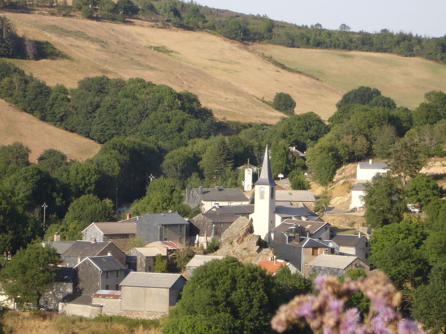
The harsh climate of the Alban mountains and the upper valley of the Dadou forced inhabitants to seek protection in natural sites. The church of Saint-Salvi-de-Carcavès, for example, shelters behind a massive rocky outcrop that shields it from the prevailing winds. Its position illustrates a common strategy that gives the area a mountain character, even though life unfolds at altitudes of “only” 600 to 800 metres. The houses, both in their design and layout, share similarities with dwellings found higher up in the mountains.
A land as demanding as its people, the upper valley of the Dadou forms a landscape without compromise. And even though modern communication has recently opened it to the world, the people here still know how to merge with their environment in order to make the best use of it.
The harsh climate of the Alban mountains and the upper valley of the Dadou forced inhabitants to seek protection in natural sites. The church of Saint-Salvi-de-Carcavès, for example, shelters behind a massive rocky outcrop that shields it from the prevailing winds. Its position illustrates a common strategy that gives the area a mountain character, even though life unfolds at altitudes of “only” 600 to 800 metres. The houses, both in their design and layout, share similarities with dwellings found higher up in the mountains.
A land as demanding as its people, the upper valley of the Dadou forms a landscape without compromise. And even though modern communication has recently opened it to the world, the people here still know how to merge with their environment in order to make the best use of it.
Pot
Église Saint-Salvi-de-Carcavés
(703 m)
Kraj čaščenja
0.0 km
Saint-Salvi-de-Carcavès
(699 m)
Vas
0.1 km
Les Trois Fonds
(808 m)
Koridor/teren
12.3 km
Saint-Salvi-de-Carcavès
(699 m)
Vas
16.8 km
Église Saint-Salvi-de-Carcavés
(703 m)
Kraj čaščenja
16.8 km
Pot
Saint-Salvi-de-Carcavès
težko
Pohodništvo
16.91
km
Église Saint-Salvi-de-Carcavés
(703 m)
Kraj čaščenja
0.0 km
Saint-Salvi-de-Carcavès
(699 m)
Vas
0.1 km
Les Trois Fonds
(808 m)
Koridor/teren
12.3 km
Saint-Salvi-de-Carcavès
(699 m)
Vas
16.8 km
Église Saint-Salvi-de-Carcavés
(703 m)
Kraj čaščenja
16.8 km


Informacije o poti
Pot
Point 1: Descend into the village via the alley on the right. Near the Associations' house, take a right. Continue descending along the road. Leave a path on the left. After 1km, climb to the farm of La Micalié. Continue along the wide path. At the top, take left by the barn. Cross the stream and reach La Combe-Basse. Follow the road for 1km.
Point 2: At the bend, take left. At the crossroads of tracks, take the one on the right, then after a few meters, turn right into the woods. At a bend, leave the left track. Lower down, go between two rows of spruces to reach the path at the bottom of the valley. Head left into the pasture area and cross four stile gates.
Point 3: On the road in front of Muratel, go left. At the fork at Gaillardac, straight ahead. Take the first road on the right towards Font-Leval. At the fork of Font-Leval, continue straight ahead.
Point 4: Attention! route crossing. At the bend, climb the left track. At the crossroads, continue straight ahead. At the hilltop, cross two stile gates. At the first two forks, continue straight ahead; 15m after the second, veer right down the slope. To the left at the bottom of the valley. In front of the meadow, make a right hairpin turn. Follow the stream. Cross the bridge. Close the fence. Climb straight ahead. 30m after the hilltop, turn left. Follow and close the fence. At the fork, take left.
Point 5: At the road junction, cross towards the hedge opposite. At the intersection, turn right; 25m later, left; then 30m further, left again. Go straight ahead above La Falgassié. At the bend, turn left. At the fork, turn right. At the junction at the bottom of the valley, make a right-left. Continue straight ahead.
Point 2: At the bend, take left. At the crossroads of tracks, take the one on the right, then after a few meters, turn right into the woods. At a bend, leave the left track. Lower down, go between two rows of spruces to reach the path at the bottom of the valley. Head left into the pasture area and cross four stile gates.
Point 3: On the road in front of Muratel, go left. At the fork at Gaillardac, straight ahead. Take the first road on the right towards Font-Leval. At the fork of Font-Leval, continue straight ahead.
Point 4: Attention! route crossing. At the bend, climb the left track. At the crossroads, continue straight ahead. At the hilltop, cross two stile gates. At the first two forks, continue straight ahead; 15m after the second, veer right down the slope. To the left at the bottom of the valley. In front of the meadow, make a right hairpin turn. Follow the stream. Cross the bridge. Close the fence. Climb straight ahead. 30m after the hilltop, turn left. Follow and close the fence. At the fork, take left.
Point 5: At the road junction, cross towards the hedge opposite. At the intersection, turn right; 25m later, left; then 30m further, left again. Go straight ahead above La Falgassié. At the bend, turn left. At the fork, turn right. At the junction at the bottom of the valley, make a right-left. Continue straight ahead.
Še ni pregledov
Priljubljeni izleti v okolici
-
CAR TOURISTIC ROUTE - MONTS DE LACAUNE
svetlobaMotorno kolo 154.6 km -
Hikes in the Trivalle and their variations
svetlobaPohodništvo 6.92 km -
Circuit no. 1 MTB - Lacaune les Bains sector
težkoMountainbike 32.7 km -
Tour du Tarn on horseback: Paulinet / Mont-Roc
srednjaJahanje 15.5 km -
GR36 ® - Crossing Tarn from North to South
težkoPohodništvo 236.1 km -
Huit de Massals
težkoPohodništvo 12.3 km -
Tour du Tarn à cheval : Alban / Paulinet
srednjaJahanje 10.9 km -
Malefayère
svetlobaPohodništvo 9.40 km -
Lou camin dels castanhals
težkoPohodništvo 18.7 km -
THE CIRCUIT OF THE MOUNTAINS - CYCLE CIRCUIT NO. 5
srednjaKolesarjenje 106.4 km

Pohodništvo in sledenje

Zaradi več kot 550.000 predlogov izletov, podrobnih zemljevidov in intuitivnega načrtovanja poti je aplikacija obvezna oprema za vse ljubitelje narave.

Ne zamudite ponudb in navdiha za naslednje počitnice
Naročite se na novice
Napaka
Zgodila se je napaka. Prosimo, poskusite znova.
Zahvaljujemo se vam za prijavo
Vaš e-poštni naslov je bil dodan na poštni seznam.
Izleti po vsej Evropi
Avstrija
Švica
Nemčija
Italija
Slovenija
Francija
Nizozemska
Belgija
Poljska
Lihtenštajn
Češka
Slovaška
Španija
Chorvátsko
Bosna in Hercegovina
Luksemburg
Andora
පෘතුගාලය
අයිස්ලන්තය
එක්සත් රාජධානිය
අයර්ලන්තය
ග්රීසිය
ඇල්බේනියාව
North Macedonia
Malta
Norway
Montenegro
Moldova
කොසෝවො
හන්ගේරියානු සමුහාණ්ඩුව
San Marino
රුමේනියාව
එස්ටෝනියා
ලැට්වියාව
බෙලාරස්
සයිප්රස්
Lithuania
Serbia
බල්ගේරියාව
Monaco
ඩෙන්මාර්කය
Sweden
ෆින්ලන්තය





