GR®Pays Les Monts de Guéret : la boucle du Loup en écomobilité
težko
Navigacija po spletni strani
Navigacija po spletni strani
Pridobite to turo v svoj mobilni telefon
GR®Pays Les Monts de Guéret : la boucle du Loup en écomobilité
težko
Pohodništvo
48.17
km
Skenirajte kodo QR in začnite navigacijo v aplikaciji bergfex.

Pohodništvo in sledenje


GR®Pays Les Monts de Guéret : la boucle du Loup en écomobilité
težko
Razdalja
48.17
km
Trajanje
13:01
h
Ascent
1,095
hm
Morska gladina
421 -
681
m
Prenos skladbe
GR®Pays Les Monts de Guéret : la boucle du Loup en écomobilité
težko
Pohodništvo
48.17
km
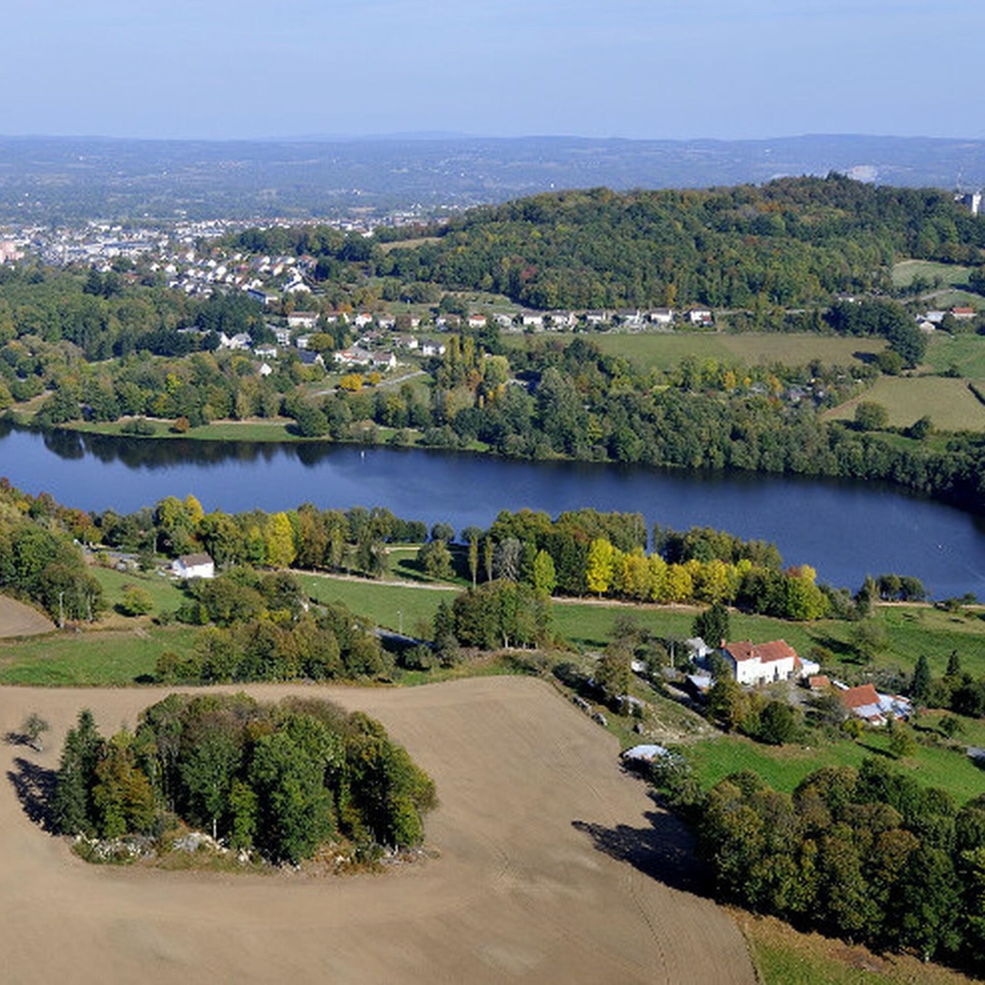
This 48.5 km route south of Guéret takes you through the Maupuy and Chabrières forest massifs. It can be completed in 2 days. In the course of challenging stages, you'll discover the stretcher stones,...
Opis
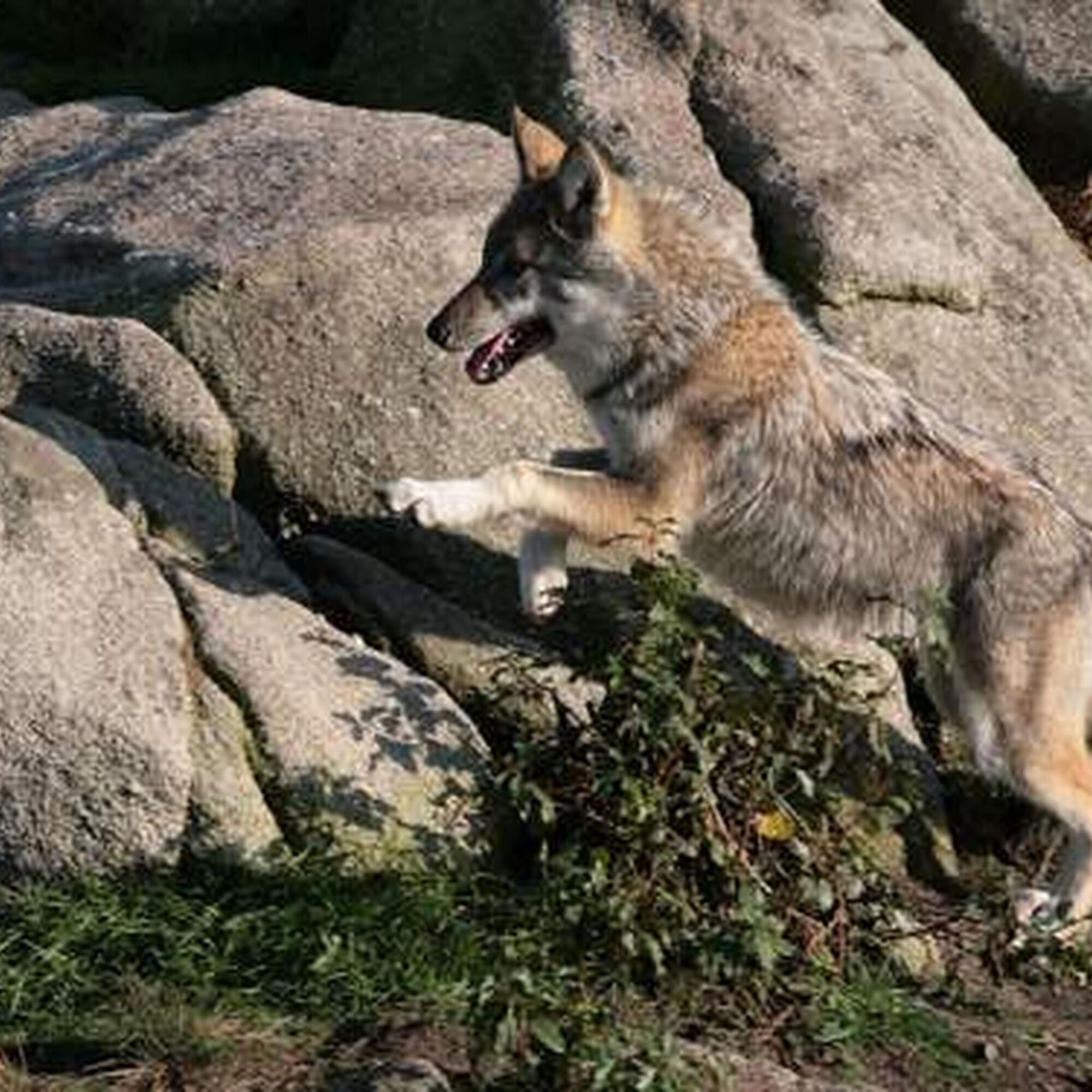
This 48.5 km route south of Guéret takes you through the Maupuy and Chabrières forest massifs. It can be completed in 2 days. In the course of challenging stages, you'll discover the stretcher stones, the arborétum of the Monts de Guéret, the legends of the Chabrières forest and its famous wolf park. It can easily be done in both directions.
This route is proposed by the Comité Régional de Randonnée Pédestre. Departing from a train station or TER bus stop, it allows you to join a walking or hiking itinerary and take a trip in ecomobility!
This route is proposed by the Comité Régional de Randonnée Pédestre. Departing from a train station or TER bus stop, it allows you to join a walking or hiking itinerary and take a trip in ecomobility!
Pot
Guéret
(455 m)
Mesto
0.4 km
Puy de Gaudy
(651 m)
Vrh
5.3 km
La Planche
(422 m)
Poravnava
7.5 km
Savennes
(590 m)
Vas
19.5 km
La Chapelle-Taillefert
(495 m)
Vas
24.0 km
Puy de Chiroux
(689 m)
Vrh
32.7 km
Église Saint-Pierre et Saint-Paul
(444 m)
Kraj čaščenja
48.0 km
Pot
GR®Pays Les Monts de Guéret : la boucle du Loup en écomobilité
težko
Pohodništvo
48.17
km
Guéret
(455 m)
Mesto
0.4 km
Pommeil
(507 m)
Poravnava
2.2 km
Le Theil
(489 m)
Poravnava
3.1 km
La Faye
(481 m)
Poravnava
3.3 km
Puy de Gaudy
(651 m)
Vrh
5.3 km
Puy de Gaudy
(649 m)
Pogled
5.5 km
Laspeyras
(471 m)
Poravnava
6.9 km
Voust
(443 m)
Poravnava
7.2 km
La Planche
(422 m)
Poravnava
7.5 km
Peuplat
(435 m)
Poravnava
7.9 km
Badant
(614 m)
Poravnava
12.2 km
Les Vergnes
(555 m)
Poravnava
18.0 km
Savennes
(590 m)
Vas
19.5 km
Reillat
(583 m)
Poravnava
20.2 km
Saint-Christophe
(506 m)
Vas
21.6 km
Influence
(488 m)
Restavracija
24.0 km
La Chapelle-Taillefert
(495 m)
Vas
24.0 km
Le Chier
(529 m)
Poravnava
24.8 km
Rebeyrolle
(475 m)
Poravnava
26.7 km
Saint-Victor-en-Marche
(479 m)
Vas
28.4 km
Église Saint-Victor
(479 m)
Kraj čaščenja
28.4 km
Le Chiroux
(541 m)
Poravnava
31.3 km
Puy de Chiroux
(689 m)
Vrh
32.7 km
Plage de Courtille
(464 m)
Restavracija
44.1 km
Guéret
(455 m)
Mesto
47.9 km
Église Saint-Pierre et Saint-Paul
(444 m)
Kraj čaščenja
48.0 km
Avtor
Zagotavlja Tourisme Creuse

Informacije o poti
Primerno za invalidske vozičke
Da
Dodatne informacije in nasveti
Dodatne informacije
Comité Régional de Randonnée Pédestre de Nouvelle-Aquitaine https://www.ffrandonnee-nouvelle-aquitaine.com/
Nasveti
Yellow and red (GRP®)
cdt64.media.tourinsoft.eu/upload/bouc...
Še ni pregledov
Priljubljeni izleti v okolici
-
Creuse cycling route
srednjaKolesarjenje na dolge razdalje 324.5 km -
GRP des Monts de Guéret - Water loop
težkoPohodništvo v daljavo 75.8 km -
Grande Traversée VTT de la Creuse (GT 23/First section)
srednjaMountainbike 263.6 km -
GRP des Monts de Guéret - Wolf Loop
težkoPohodništvo v daljavo 48.1 km -
Grande Traversée VTT de la Creuse (GT23/Second Section)
težkoMountainbike 260.7 km -
Mountain bike route No. 32 - Forêt de Chabrières
težkoMountainbike 16.5 km -
5.0
Circuit Pédestre N°15 CC : "Sur les pas des moines et des seigneurs"
svetlobaPohodništvo 10.2 km -
Trail Les rochers de Chabrières
srednjaTrailrunning 20.3 km -
Circuit de randonnée pédestre n° 17 Le Maupuy et ses Pierres Civières
srednjaPohodništvo 7.04 km -
Grande traversée VTT - La Grande Boucle
težkoMountainbike 418.6 km
Pohodništvo in sledenje

Zaradi več kot 550.000 predlogov izletov, podrobnih zemljevidov in intuitivnega načrtovanja poti je aplikacija obvezna oprema za vse ljubitelje narave.

Ne zamudite ponudb in navdiha za naslednje počitnice
Naročite se na novice
Napaka
Zgodila se je napaka. Prosimo, poskusite znova.
Zahvaljujemo se vam za prijavo
Vaš e-poštni naslov je bil dodan na poštni seznam.
Izleti po vsej Evropi
Avstrija
Švica
Nemčija
Italija
Slovenija
Francija
Nizozemska
Belgija
Poljska
Lihtenštajn
Češka
Slovaška
Španija
Chorvátsko
Bosna in Hercegovina
Luksemburg
Andora
පෘතුගාලය
අයිස්ලන්තය
එක්සත් රාජධානිය
අයර්ලන්තය
ග්රීසිය
ඇල්බේනියාව
North Macedonia
Malta
Norway
Montenegro
Moldova
කොසෝවො
හන්ගේරියානු සමුහාණ්ඩුව
San Marino
රුමේනියාව
එස්ටෝනියා
ලැට්වියාව
බෙලාරස්
සයිප්රස්
Lithuania
Serbia
බල්ගේරියාව
Monaco
ඩෙන්මාර්කය
Sweden
ෆින්ලන්තය