


Geological Circular Route Medebach-Düdinghausen
The premium trail certified with the German Hiking Seal leads through the beautiful village ensemble with historical house plaques of the “border village between Kurköln and Waldeck”, offers the panoramic...
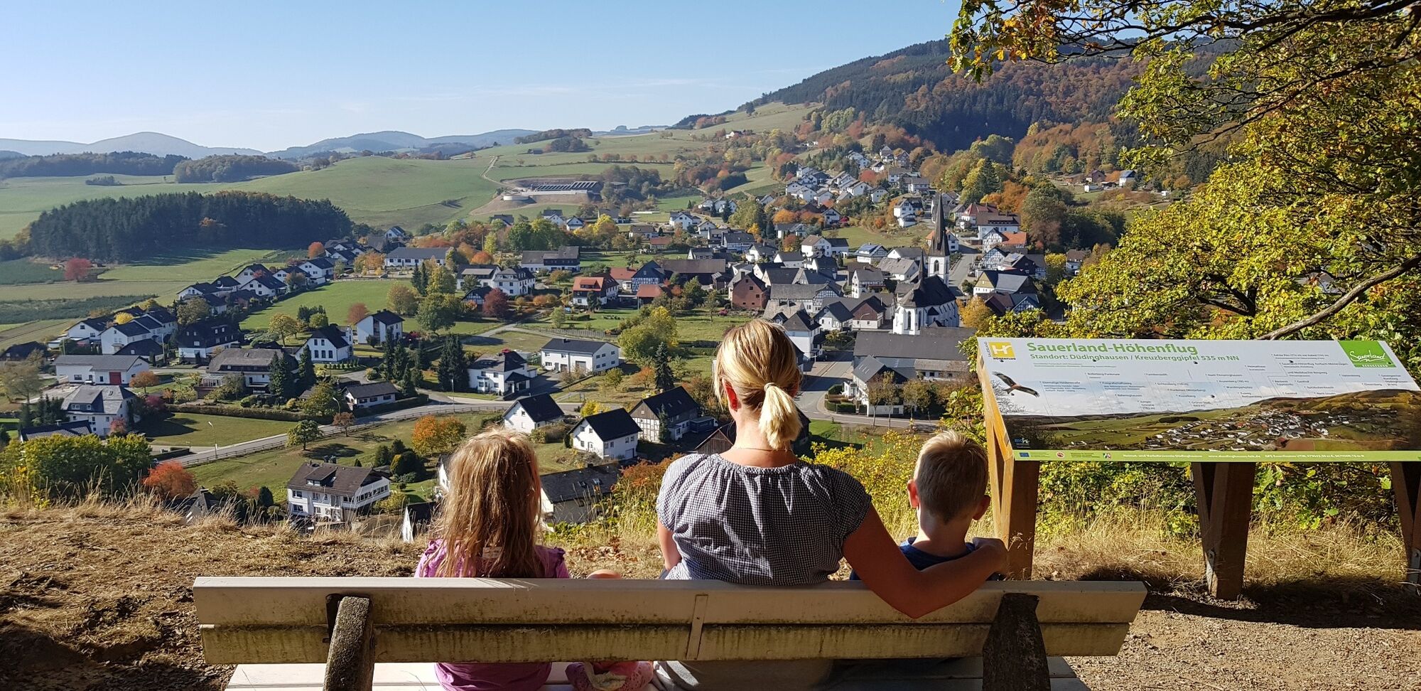
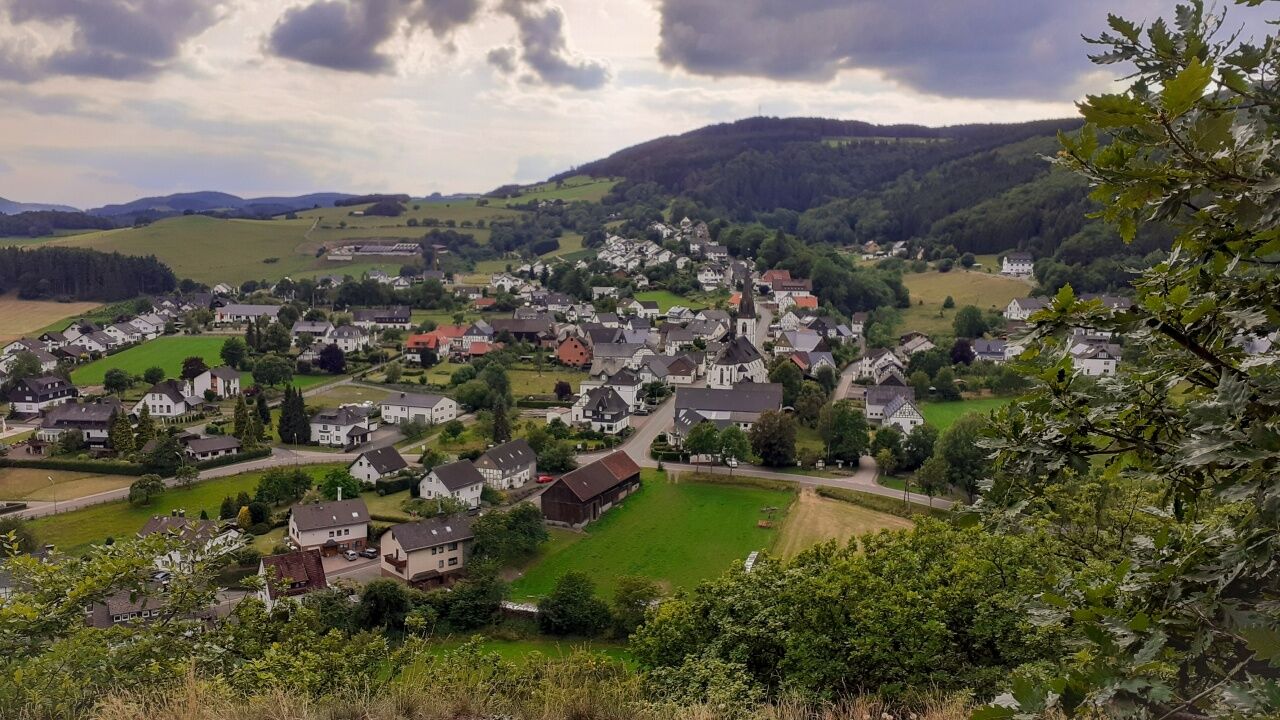
The premium trail certified with the German Hiking Seal leads through the beautiful village ensemble with historical house plaques of the “border village between Kurköln and Waldeck”, offers the panoramic viewpoint Kreuzberg with Way of the Cross and chapel. Four quarries and one gorge with information boards as well as a beech forest hollow way enable insights into earth, forest, and transport history.
Do you want to find out why Düdinghausen was a tropical bathing paradise at the equator 320 million years before Christ? Are you interested that Düdinghausen was then bombarded with lava rock by neighboring Waldeck volcanoes? And - where is the line where two geological eras meet? If your appetite is whetted, then experience an expedition on the 7 km long Geological Circular Route, which mainly runs along natural paths and trails.
On this hike you will discover:
Listed neo-Gothic church Starting board and church plaques for the historical village tour of Düdinghausen Historic Way of the Cross from 1859 Kreuzberg summit with panoramic view and chapel Vitsenböhl quarry Borghagen quarry Gerkes quarry Fault due to meeting of two geological eras Kirchen quarry Spitzbubenbusch Medieval beech forest hollow way “Meggers Holt” Riepen gorgePossible extension of the hike:
Connecting hike of about 5 km along the nature trail Kahler Pön
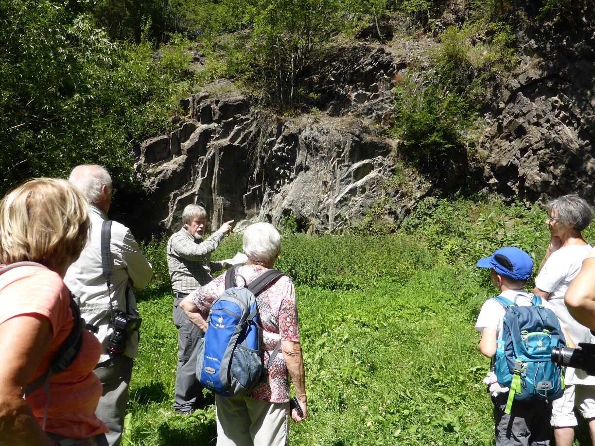
Tip: Guided Geological Tour (The Four Quarries Route)
From April to October guided hikes with the geopark guide are offered. Information about dates can be found at www.medebach-touristik.de or by phone at 02982-9218610.
Tour description: Approx. 4 km circular hike over part of the premium trail Geological Circular Route with interesting information on village history, current village situation, geology in the border area between Lower Carboniferous with tropical seas, coral reefs, and underwater volcanoes, fossil search under guidance. From Kreuzberg, enjoy a fantastic view.

The path with two steep ascents and descents, each 200 to 600 m long, is continuously marked with the cephalopod logo and equipped with information boards at 7 locations.
It starts at the signpost at the church square in the village center and initially follows together with the Sauerland Höhenflug and the Medebacher Bergweg - directly past the starting board for the historical village tour next to the church, down to the village hiking board, then northeast along the pedestrian path beside the L 854 to the cemetery. There you cross the L 854, then a stream, and follow the steeply rising historic Way of the Cross from 1859 to the Kreuzberg summit (535 m above sea level) with chapel, information boards, and stunning panoramic views.
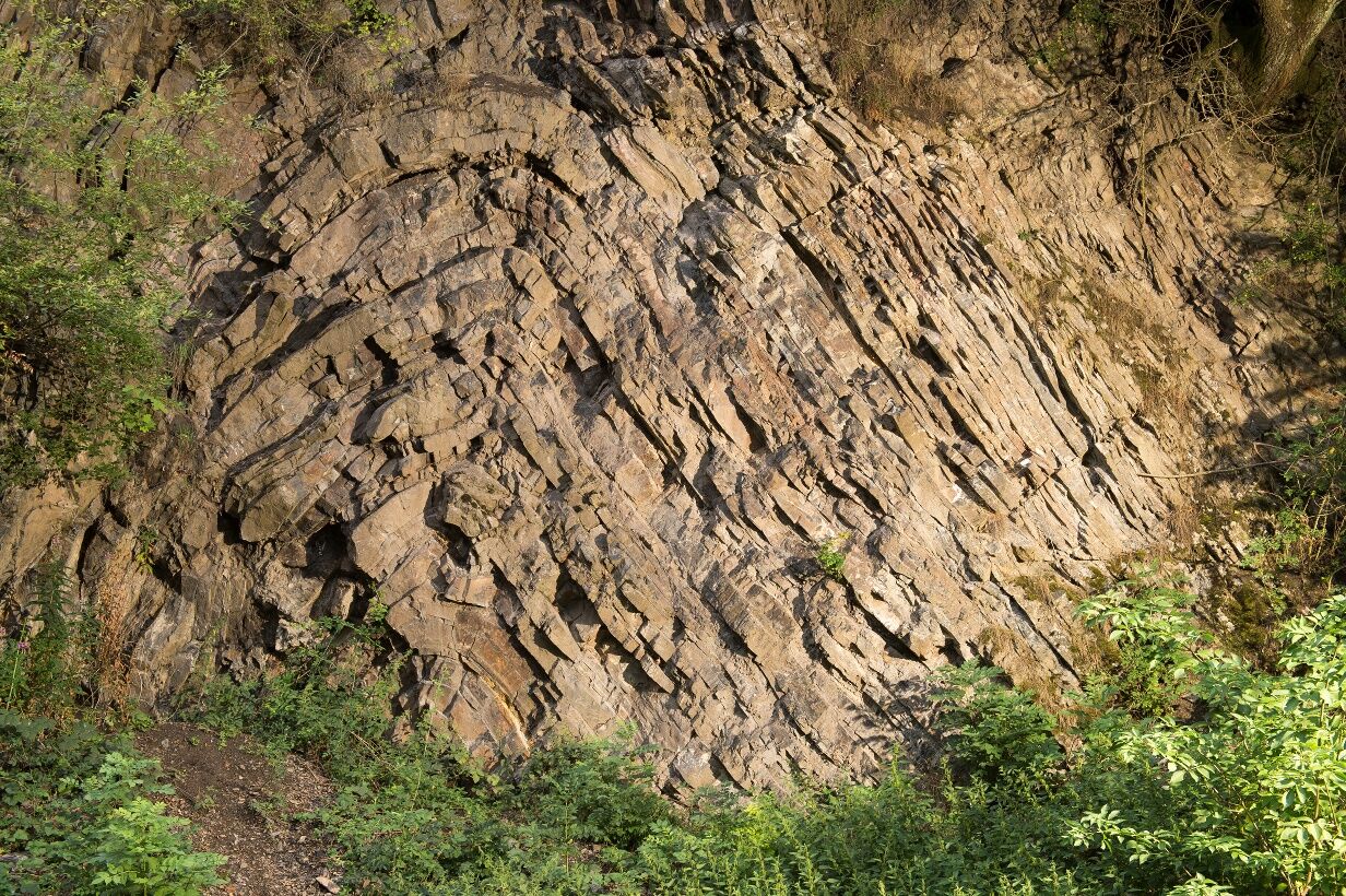
After leaving the forest, turn right and take a steep grassy descent to the south. Then you reach the Vitsenböhl quarry, walk back 100 m, and follow a valley path turning left at the edge of the Kreuzberg slope heading north. After crossing the approach path section next to station 2, you cross the embankment of the L 854, cross it, and immediately arrive at the Borghagen quarry (Geotope of the Year 2005).
You continue along the valley edge path heading north, which eventually leads into a trail, then encounter a paved path, which you follow steeply uphill to the northeast. Just before the top, turn sharply right (southwest) to make a detour to the Gerkes quarry 100 m away.
Return the 100 m and then continue to the nearby Wede parking lot. Here you turn left (north) - now also on the Uplandsteig quality hiking trail - and follow a grassy side path 100 m along the L 854. Then the hike goes west, first along the forest edge, then left into the beech forest. After 200 m you notice a trickle on the right side of the path. Geologically, this represents a fault where two geological eras meet, the Carboniferous (our previous environment) and the Devonian. Shortly afterwards, you reach the Kirchen quarry.
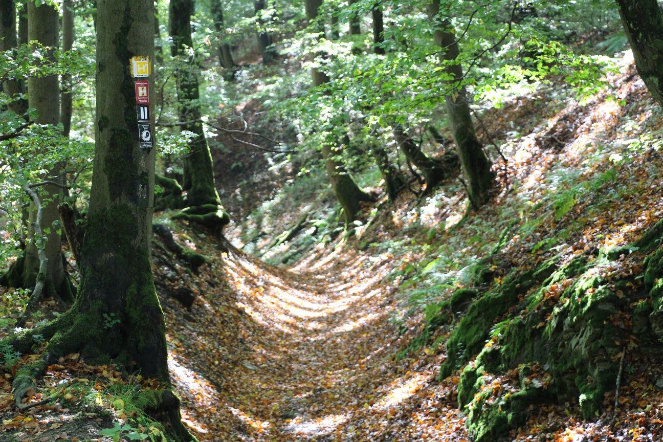
After that, it goes about 1 km through different forest types, occasionally interrupted by wide views, to Spitzbubenbusch, a medieval trading place on the border between Kurköln and Waldeck. Shortly afterwards, the Uplandsteig quality hiking trail turns sharply right towards the north; however, you continue straight for another 50 m before turning left for a 400 m long descent via the medieval Meggers Holt hollow way. At the end of the path, you have a nice view of Oberschledorn and, in the distance on the left, of Goldhausen on the Korbach Eisenberg.
After another 200 m long steep descent along the forest edge, you then turn sharply left (north) at the signpost, follow a hillside path with beautiful southern views, and then reach the foot bath (a cozy rest area with a view of Goldhausen). Shortly after reaching the narrow paved path, turn right into a sloping meadow path lined with hedges. In the beech forest, you cross the Riepenbach gorge and then return to the village.
Da
Sturdy footwear and weather-appropriate clothing.
The path is not suitable for strollers.
Only difficult with deep snow (possibly from December to March)
Current information on our forests - The bark beetle and its consequences
Forest owners are working on necessary measures in the forests and the removal of damaged wood. However, these tasks cannot be accomplished quickly due to the extent. Clearing and reforestation of the damaged forest stands will therefore take a long time and may lead to restrictions such as closures and detours in the forests. This should always be considered when visiting the forests.
We therefore appeal to everyone who cares about the forest:
Please understand that extensive forest work is necessary in the current situation and that it accompanies your forest experience at this time. Be especially attentive during your leisure activities and observe prevailing instructions and any prohibitions.Please be considerate ...
B 251 to Usseln, then L 854 to Düdinghausen (5 km)
From Olsberg/Winterberg via Küstelberg/Deifeld
From Willingen: Bus R46 (RLG): Willingen-Düdinghausen
From Winterberg: Bus R48 (RLG): Winterberg-Düdinghausen
From Korbach: Bus 550 (NVV): Korbach-Medebach / change to R48 towards Düdinghausen
From Frankenberg (Eder): Bus 530 (NVV): Frankenberg-Lichtenfels-Medebach / change to R46 towards Düdinghausen
Parking lot Heimathaus at L 854; from there follow the sign „Heimathaus“; church square is 20 m above the Heimathaus
Watch the shavings fly at the woodturning museum! From April to October, the local heritage house with its museum café is open on Thursdays from 3 pm.
Priljubljeni izleti v okolici
- 4,7
Bruchhauser Steine B1
srednjaPohodništvo 11,8 km - 5,0
Circular route Skywalk/Hill - Ettelsberg
svetlobaPohodništvo 4,10 km - 4,5
Bruchhausener Steine
težkoPohodništvo 5,15 km - 5,0
Winterberg - rund um den Kreuzberg
svetlobaPohodništvo 10,9 km - 5,0
Rundwanderung Ruhrquelle Winterberg
svetlobaPohodništvo 3,74 km - 5,0
Rothaarsteig-Spur - Grönebacher Dorfpfad
srednjaPohodništvo 10,6 km - 4,8
Rundwanderung Diemelsee
svetlobaPohodništvo 8,54 km - 4,0
Willingen (W8)
srednjaPohodništvo 12,9 km - 5,0
Willingen (W6)
srednjaPohodništvo 12,9 km Winterberger Hochtour
težkoTematska pot 90,7 km
Pohodništvo in sledenje


Ne zamudite ponudb in navdiha za naslednje počitnice
Vaš e-poštni naslov je bil dodan na poštni seznam.