







Cima Viola 3374m
The most elegant and alpinistically complete peak in the municipality of Grosio. Its northern slope is ice-covered, ''irregular plateau-canal'' that Nangeroni said is unique in its shape in the Alps. While...
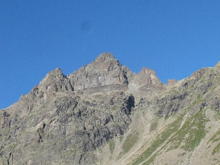
The most elegant and alpinistically complete peak in the municipality of Grosio. Its northern slope is ice-covered, ''irregular plateau-canal'' that Nangeroni said is unique in its shape in the Alps. While on its southern slope a compact and daring 500-meter wall of rock offers playground for experienced and gifted climbers. This is a summit of great value both from an alpine point of view and in terms of its panorama position. In fact it enjoys an excellent vantage point over the surrounding mountain ranges. The first ascent was made by fellow countryman Dr. Bartolomeo Sassella solo on September 27, 1875. From the Capanna Dosde' in direction E ascend the moraines and snowfield of the basin dominated by the 3180m elevation of the SW ridge. Walk diagonally on the S side of the W ridge to reach the basin until you reach on the left a debris gully(sometimes snow-covered) thanks to which you bypass the rocky strip and climb over the ridge to reach the base of the glacier. Having passed the steepest section of the same, you continue on the ice plateau where the Dosde' W glacier, which covers the entire northern slope of the mountain, lies. Crossed in the direction of the notch between the SW3289m antecedent and the summit canopy, continue over easy rocks mixed with snow to our summit.

Vermolera - Dosde' Pass - Cima Viola
glacier material
PD
Pridobite vpogled
Vedno v živo na mestu z več kot 9.500 spletnimi kamerami. bergfex Kot uporabnik Pro si lahko zdaj ogledate ustrezne spletne kamere za številne izlete v aplikaciji izleti iz. Tako si lahko neposredno ogledate trenutne razmere.
Priljubljeni izleti v okolici
-
5.0
Mountain hike to Lagh da Saoseo
težkoPohodništvo 15.0 km -
5.0
Lagalb - Val Minor - Motta Bianca - Lagalb
srednjaPohodništvo 9.80 km -
4.8
Val Nera Waterfalls
svetlobaPohodništvo 5.70 km -
4.3
Lago Bianco
Pohodništvo 7.91 km -
5.0
Ospizio Bernina Station - Alp Grüm (-Cavaglia)
svetlobaPohodništvo 4.97 km -
4.5
Da Sfazù a lago Saoseo
svetlobaPohodništvo 11.0 km -
Alp Grüm - Cavaglia - Poschiavo
srednjaPohodništvo 9.41 km -
5.0
53 Bernina Tour Switzerland: Stage 1 Poschiavo-Bernina Pass
srednjaPohodništvo 14.6 km -
4.0
Giro del Lago - Le prese - Miralago
svetlobaPohodništvo 7.43 km -
Mount of Mines
srednjaSmučarska tura 4.78 km
Pohodništvo in sledenje


Ne zamudite ponudb in navdiha za naslednje počitnice
Vaš e-poštni naslov je bil dodan na poštni seznam.





