







Circuit des croix

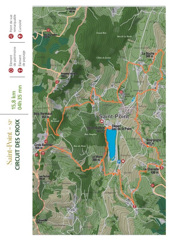
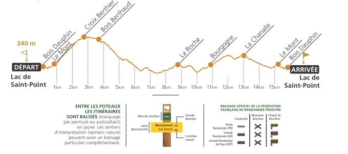
1 - From the war memorial, walk along the public garden, turn right and climb up to the Château de Saint-Point, church (12th century) and old cemetery (Saint-Donat cross). Opposite the castle gate, walk...
1 - From the war memorial, walk along the public garden, turn right and climb up to the Château de Saint-Point, church (12th century) and old cemetery (Saint-Donat cross). Opposite the castle gate, walk down the road. Cross the bridge and take the stony path on the right as far as the Croix de la Roche. Cross the D22. At the lavoir de la Roche, turn left up the grassy path. Keep right as far as the road and follow it to the left. Cross the farm and come to the "broken" cross at Merloux.
2 - Go up to the right and after 100 m, continue to the right. Follow the road to the right, passing a farm. At the 1st house in Joux, turn left, do the same at the crow's-foot and reach the Joux cross. Go straight ahead, cross a road and continue along a track. Turn right at the wash-house. Cross a road and head downhill. At the houses, turn left to reach the Rocher cross, with a view of the castle.
3 - Take the road up to Le Rocher. At the 1st crossroads, go straight ahead, then left at the second crossroads. Take the road on the left as far as Bourgogne. Go past the Bourgogne cross and, at the fortified farm exit, continue straight on along a track. Go through Pré-Magnien, stay on the road, past the Chanalle cross, and through this hamlet.
4 - At the exit, turn left onto the track leading to Gorze. Go straight on until you reach the road, which you turn left onto as far as Prost. At the crossroads, turn right and continue as far as the Croix du Prost. Go back the way you came, turn left at the crossroads, pass the sawmill and go down to Vers Ville. Continue downhill on the left-hand side of the road, taking a right-hand turn-off towards the lake and rejoining the D22.
5 - Cross the road and head up to Mont. Walk along the wall of a town house and turn right at the second track. After 200 m, take the right-hand path into the forest. Follow the road to the right. At the crossroads, turn left and, at the crow's feet, continue to the right until you reach the Berthier cross.
6 - Turn right and follow the GR to the road. Follow it down to the right. At the Champ Philippe hairpin, keep left until you reach the first grassy track. Follow it to the right between pastures and reach a farm. Turn left down the road for 50 m, then left up a track that leads to the Chagny cross.
7 - Leaving the cross on your left, walk down the road to Rue du Frêne, keep right as far as the crossroads. Go down the track opposite, leaving the first house on the right. Cross the road and take the track opposite which leads to Saint-Point.

In case of emergency, dial 112
Consider carpooling
Parking near the starting point
Priljubljeni izleti v okolici
- 5.0
Les secrets de la Roche de Solutré
srednjaPohodništvo 3.97 km CycloRoute71 - Etape 1 de Mâcon à Cormatin
srednjaKolesarjenje 51.1 kmLes sentiers belles vues - Saint-Amour-Bellevue
srednjaPohodništvo 12.3 kmLes confidences de la Roche de Vergisson
svetlobaPohodništvo 3.02 kmCycloRoute71 - Etape 11 de La Clayette à Cluny
srednjaKolesarjenje 56.8 kmEscapade nature sans voiture - De Mâcon Loché à La Grange du Bois
srednjaPohodništvo 13.8 kmEscapade Nature au cœur du Grand Site de France Solutré Pouilly Vergisson
srednjaPohodništvo 29.9 kmLes crêtes boisées du Mâconnais
srednjaMountainbike 170.8 kmLes Chemins de Saint-Jacques de Compostelle de Cluny au Puy-en-Velay
svetlobaPohodništvo 23.5 kmCycloRoute71 - Etape 12 de Cluny à Mâcon
srednjaKolesarjenje 66.2 km
Pohodništvo in sledenje


Ne zamudite ponudb in navdiha za naslednje počitnice
Vaš e-poštni naslov je bil dodan na poštni seznam.





