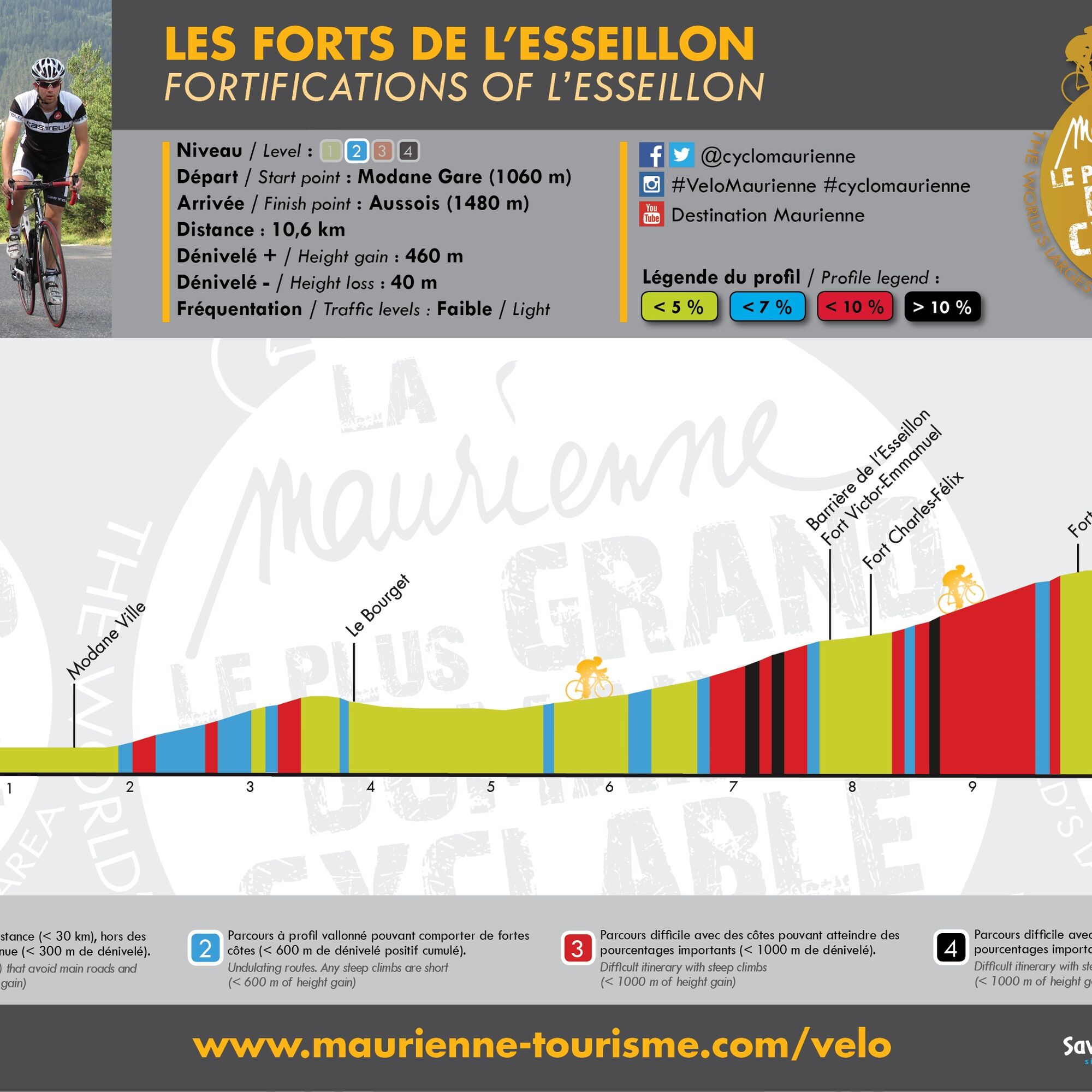
Les Forts de l'Esseillon
svetloba
Pridobite to turo v svoj mobilni telefon
Les Forts de l'Esseillon
svetloba
Cestno kolo
10,56
km
Skenirajte kodo QR in začnite navigacijo v aplikaciji bergfex.

Pohodništvo in sledenje


Les Forts de l'Esseillon
svetloba
Razdalja
10,56
km
Trajanje
01:00
h
Ascent
402
hm
Morska gladina
1.053 -
1.477
m
Prenos skladbe
Les Forts de l'Esseillon
svetloba
Cestno kolo
10,56
km
This ancient route de l'Esseillon winds between Le Bourget and Aussois, taking in the waterfall and the chapel of Saint-Benoît (located in the commune of Avrieux but not in the village), then the Victor-Emmanuel,...
Opis
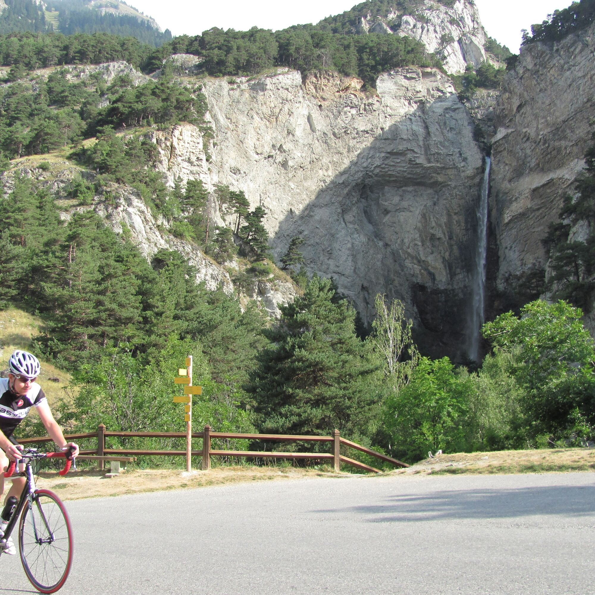
This ancient route de l'Esseillon winds between Le Bourget and Aussois, taking in the waterfall and the chapel of Saint-Benoît (located in the commune of Avrieux but not in the village), then the Victor-Emmanuel, Charles-Félix, Marie-Christine and Charles-Albert forts.
The road on this route is moderately busy, and in generally good to fair condition in places. You can only use it in the upward direction (Modane-Le Bourget-Aussois) and return via Aussois to Modane or Le Bourget.)
There are several drinking water points (at Cascade Saint Benoît, near Fort Victor Emmanuel and three others in the village of Aussois), two refreshment points (Modane and at the finish) and two repair points (Modane and Aussois).
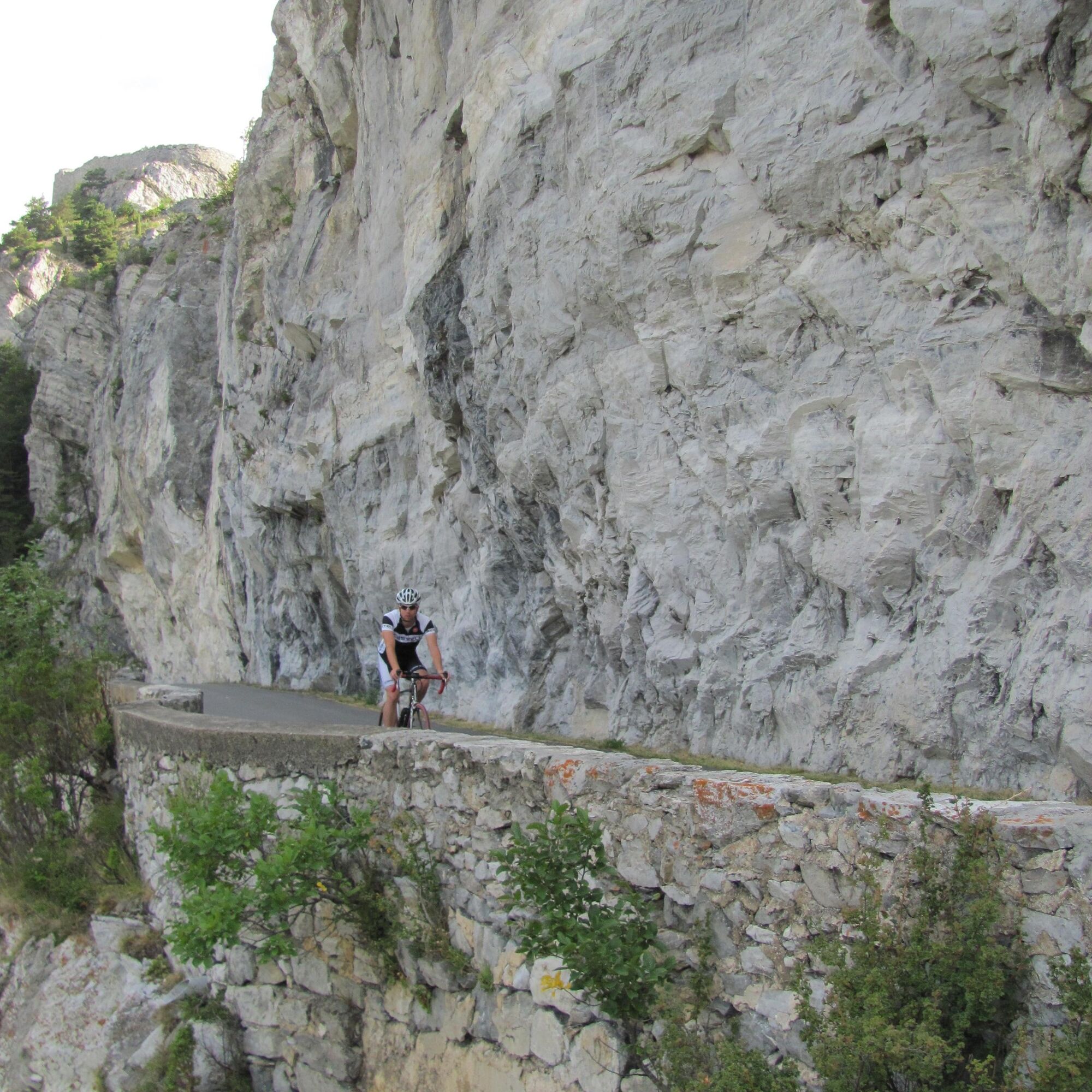
The route boasts an interesting natural heritage, including the Rocher des Amoureux and the Cascade Saint Benoît. It also boasts an important cultural heritage, including the Modane Museobar, the Esseillon forts and the village center of Aussois.
The road on this route is moderately busy, and in generally good to fair condition in places. You can only use it in the upward direction (Modane-Le Bourget-Aussois) and return via Aussois to Modane or Le Bourget.)
There are several drinking water points (at Cascade Saint Benoît, near Fort Victor Emmanuel and three others in the village of Aussois), two refreshment points (Modane and at the finish) and two repair points (Modane and Aussois).
The route boasts an interesting natural heritage, including the Rocher des Amoureux and the Cascade Saint Benoît. It also boasts an important cultural heritage, including the Modane Museobar, the Esseillon forts and the village center of Aussois.
Pot
Jardin public
(1.060 m)
Igrišče
1,3 km
Modane
(1.068 m)
Vas
1,4 km
Église Saint-Pierre-aux-Liens
(1.154 m)
Kraj čaščenja
4,2 km
Col de l'Esseillon
(1.333 m)
Gorski prelaz
7,4 km
Église Notre-Dame-de-l'Assomption
(1.481 m)
Kraj čaščenja
10,4 km
Aussois
(1.483 m)
Vas
10,5 km
Pot
Les Forts de l'Esseillon
svetloba
Cestno kolo
10,56
km
Modane
(1.057 m)
Železniška postaja
0,1 km
Jardin public
(1.060 m)
Igrišče
1,3 km
Modane
(1.068 m)
Vas
1,4 km
Villarodin-Bourget
(1.157 m)
Vas
4,1 km
Église Saint-Pierre-aux-Liens
(1.154 m)
Kraj čaščenja
4,2 km
Belvédère de la Tournaz
(1.153 m)
Pogled
5,2 km
Avrieux
(1.105 m)
Vas
5,9 km
Col de l'Esseillon
(1.333 m)
Gorski prelaz
7,4 km
Église Notre-Dame-de-l'Assomption
(1.481 m)
Kraj čaščenja
10,4 km
Aussois
(1.483 m)
Vas
10,5 km
Avtor
Zagotavlja Haute Maurienne Vanoise Tourisme
Za ogled Les Forts de l'Esseillon poskrbi outdooractive.com.

Skupna turneja
Les Forts de l'Esseillon
svetloba
Cestno kolo
10,56
km
Napaka
Zgodila se je napaka. Prosimo, poskusite znova.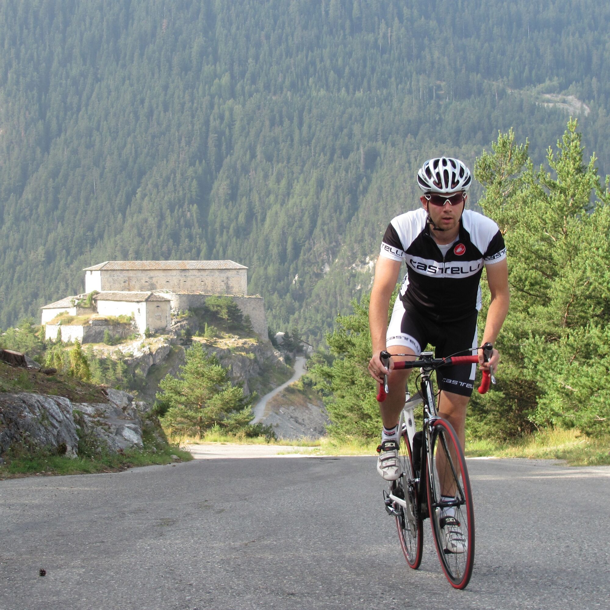
Informacije o poti
Enosmerna tura
Da
Varnostna navodila
In case of emergency, call 112
Dodatne informacije in nasveti
Dodatne informacije
APIDAE Tourism data updated on 07/28/2021 by "Maurienne Tourisme".
An error on this file? Write to the owner referencing these details:
File name: Les Forts de l'Esseillon | File ID: 758215 | URL (link) of this Outdooractive page.
An error on this file? Write to the owner referencing these details:
File name: Les Forts de l'Esseillon | File ID: 758215 | URL (link) of this Outdooractive page.
Še ni pregledov
Priljubljeni izleti v okolici
- 5,0
BARDONECCHIA Colle Sommeiller
srednjaMountainbike 25,4 km - 4,5
BARDONECCHIA Walter Bonatti Path - Grange della Rho
srednjaPohodništvo 6,06 km - 5,0
BARDONECCHIA Decauville
srednjaPohodništvo 7,29 km BARDONECCHIA Monte Jafferau
težkoPohodništvo 11,6 km- 4,0
BARDONECCHIA Sentiero dei Cosetti by Luciano Ferraris
svetlobaPohodništvo 3,24 km BARDONECCHIA Rochemolles Dam - Scarfiotti Refuge
srednjaPohodništvo 7,77 kmBARDONECCHIA Frejusia Basins - Decauville - Rochemolles Dam
svetlobaMountainbike 7,54 km- 5,0
BARDONECCHIA Caserma L - Pian dei Morti
težkoPohodništvo 7,04 km - 5,0
BARDONECCHIA Decauville
svetlobaSnežni čevlji 4,11 km - 5,0
Goldtoni - Alpenbogen A070 Refuge du Mont Thabor-Vallee Etroite
srednjaPohodništvo v daljavo 21,5 km
Pohodništvo in sledenje

Zaradi več kot 550.000 predlogov izletov, podrobnih zemljevidov in intuitivnega načrtovanja poti je aplikacija obvezna oprema za vse ljubitelje narave.

Ne zamudite ponudb in navdiha za naslednje počitnice
Naročite se na novice
Napaka
Zgodila se je napaka. Prosimo, poskusite znova.Zahvaljujemo se vam za prijavo
Vaš e-poštni naslov je bil dodan na poštni seznam.
Izleti po vsej Evropi
Avstrija Švica Nemčija Italija Slovenija Francija Nizozemska Belgija Poljska Lihtenštajn Češka Slovaška Španija Chorvátsko Bosna in Hercegovina Luksemburg Andora පෘතුගාලය අයිස්ලන්තය එක්සත් රාජධානිය අයර්ලන්තය ග්රීසිය ඇල්බේනියාව North Macedonia Malta Norway Montenegro Moldova කොසෝවො හන්ගේරියානු සමුහාණ්ඩුව San Marino රුමේනියාව එස්ටෝනියා ලැට්වියාව බෙලාරස් සයිප්රස් Lithuania Serbia බල්ගේරියාව Monaco ඩෙන්මාර්කය Sweden ෆින්ලන්තය