


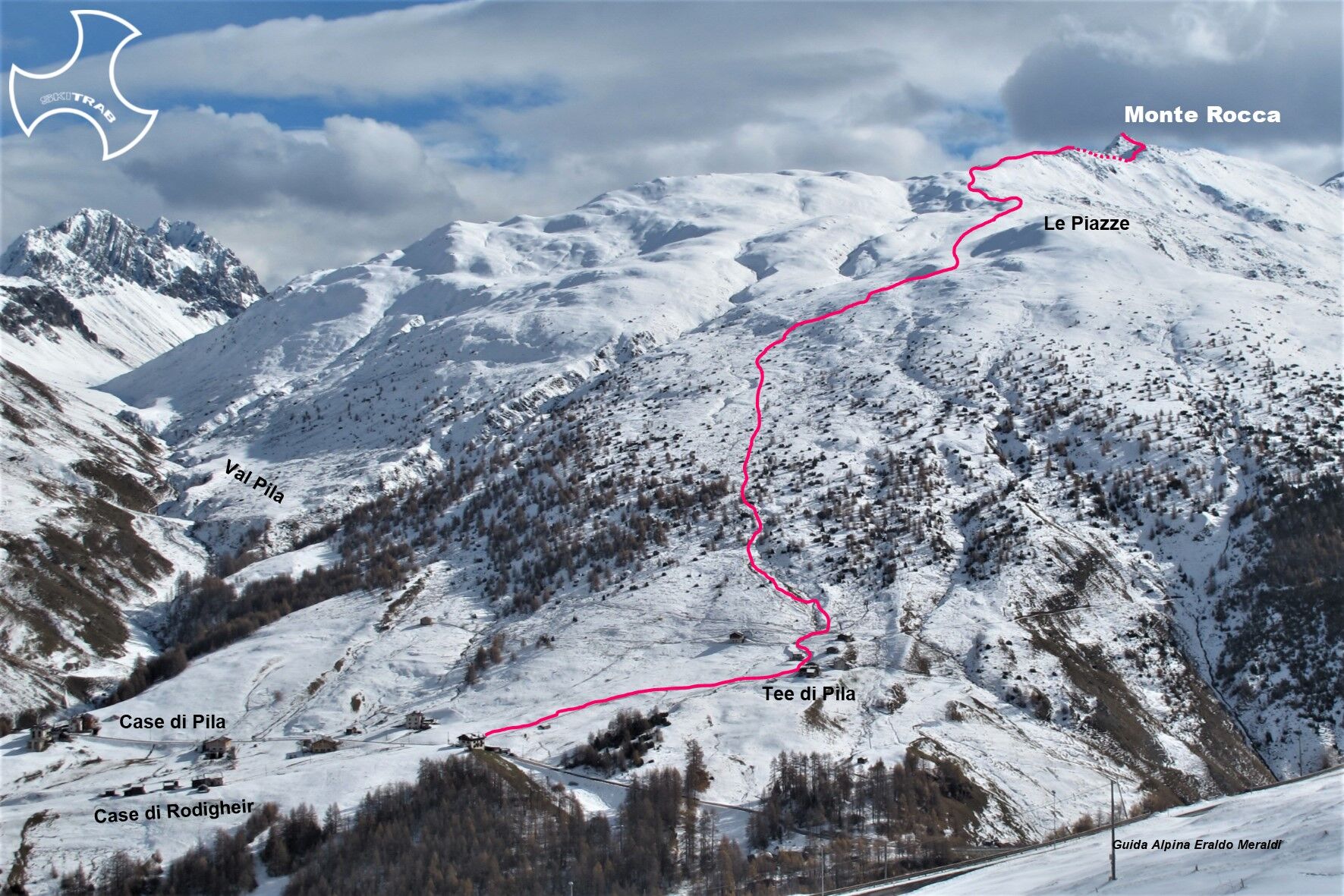
Mount Rock


From the Baite di Rodigheir in a S-E direction take you to the vicinity of the Tee di Pila and from here enter the sparse forest above. More or less follow the ridge to the right, or even to the left,...
From the Baite di Rodigheir in a S-E direction take you to the vicinity of the Tee di Pila and from here enter the sparse forest above. More or less follow the ridge to the right, or even to the left, until you come around to the right or left of Dosso Le Piazze at 2458 m. From here, again without an obligatory path, but always staying a little to the right, you will arrive at elevation 2746 m. This is the point where most ski mountaineers stop, which is about 200 meters as the crow flies from the summit. Passing instead a little lower to the left of this point, you continue in a S-E direction losing a few meters of elevation gain to the lowest point of the ridge. You then climb a short, steep little valley thus arriving at the base of the final section of the climb. This short section, being very steep, can be climbed on foot, or with skis if there is a lot of snow, given the presence of several rocky outcrops.

Niblogo, Shepherd's Hut, High Yoke, Mount Zebru'.
Self-rescue equipment (ARTVA, shovel and probe).
The route description and trail are approximate and should be verified on site depending on the condition of the snowpack present during the hike.
Because this is a hike in a snowy mountain environment at high altitudes subject to continually changing snowpack conditions, it is advisable to have adequate experience in ski mountaineering, knowledge of the area, and up-to-date information on snow conditions.
Accompaniment with a professional guide is recommended.
Several parking spaces at the start.
The route description and trail are approximate and should be verified on site depending on the condition of the snowpack present during the hike.
Because this is a hike in a snowy mountain environment at high altitudes subject to continually changing snowpack conditions, it is advisable to have adequate experience in ski mountaineering, knowledge of the area, and up-to-date information on snow conditions.
Accompaniment with a professional guide is recommended.
Priljubljeni izleti v okolici
- 3,0
Val Mora - A sense of the Canadian wilderness
srednjaPohodništvo21,6 km - 5,0
Munt la Schera - Nationalpark
srednjaPohodništvo13,1 km Süsom Givè - Piz Daint - Alp Buffalora
srednjaPohodništvo11,6 km- 5,0
Energy2Run Cancano
srednjaTrailrunning19,1 km - 4,0
Nationalpark: Munt la Schera
srednjaPohodništvo12,6 km - 5,0
Crap da la Pare' with Joëlette
svetlobaPohodništvo4,58 km - 5,0
National Park: Peaceful Hike through the Spöltal Valley
svetlobaPohodništvo7,56 km Umbrail Pass - Piz Umbrail - Lai da Rims - Praveder - Prà da Vau
težkoPohodništvo15,3 km- 4,0
19 Alta-Rezia-Tour vom Umbrailpass
srednjaE-MTB59,7 km - 5,0
Mount Staircase Ring
srednjaPohodništvo7,53 km
Pohodništvo in sledenje


Ne zamudite ponudb in navdiha za naslednje počitnice
Vaš e-poštni naslov je bil dodan na poštni seznam.