


GE_28 Ring path of Baiarda (Sentiero Frassati)


from Acquasanta railway station (213 m) walk uphill towards Colla di Prà. You soon reach a crossroads where you take the road to the left which crosses the Condotti Stream by a bridge. Here you find two...
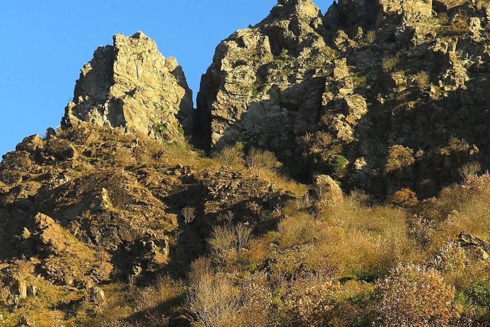
from Acquasanta railway station (213 m) walk uphill towards Colla di Prà. You soon reach a crossroads where you take the road to the left which crosses the Condotti Stream by a bridge. Here you find two crossroads where you keep the left in both of them, walking on a road which becomes unpaved and descends to Piano Pezzolo (242 m). Pass the last houses and carry on walking on the signed footpath which goes northwards. After a short descents you enter the valley of Baiardetta Stream. In half a kilometer leave the trail sign “red line and dot” to Punta Martin and take a footpath on the right with the white-red trail sign of Sentiero Frassati which rises through scattered pines and shrubs. The trail turns left (north-east) and rises diagonally towards the rocky peaks of Baiarda. At Fontanin (410 m) there is a crossroads: take the footpath on the right and soon reach the old stone quarries. Sentiero Frassati footpath continues along the hillside southwards and after a panoramic point of view it reaches the crossroads of Colletta di Termi (420 m). Here turn left and walk uphill along the south-western ridge of Punta Pietralunga, which requires some care as the footpath is steep and strenuous, with occasional exposed stretches, Pass the rocky Punta Pietralunga with a cross on top and reach the small Cappella della Baiarda chapel (703 m) located on a very panoramic spot in the maritime side of the ridge (2-2.15 hours from Acquasanta station). From the chapel, Sentiero Frassati diagonally descends towards east/north-east in the southern side as far as the trail sign “empty red square”. Turning right you cross Rio Condotti Stream, then walk downhill southwards through scattered pines. At another crossroads leave the “empty red square” trail sign and continue on Sentiero Frassati which descends in the little valley of Rio Condotti. You ford the Rio Condotti Stream twice and walk downhill along the left side of the valley before joining a wider level footpath which takes to Colla di Pra (318 m). Here you find the paved road which you follow downhill as far as Acquasanta station (1.15 hours from Cappella della Baiarda).

by train get off at Acquasanta station (Genova-Acqui railway line).
from Voltri motorway exit (Genova-Savona motorway) turn right to Voltri and then take the road to Ovada: after c. 2 km turn right to Acquasanta where you park near the railway station.
Nature and Landscape * * * * * * Family * * Gourmet * * * * Culture * * * *
Priljubljeni izleti v okolici
- 5,0
Genova, giro dei forti
svetlobaPohodništvo11,0 km Punta Martin - Pegli
srednjaPohodništvo18,8 kmArenzano, Bicocca-belvedere-rio cantarena
srednjaPohodništvo8,48 kmSalita San Pantaleo-Parco Peralto-via delle Baracche-ritorno sentiero in costa
svetlobaPohodništvo8,50 kmTrail no. 20: Prato Rotondo - Passo del Faiallo
Pohodništvo9,08 kmGenova, Cappella Baiarda da Pra29/12/21
svetlobaPohodništvo9,28 kmSV_28 Itinerario ciclopedonale da Varazze ad Arenzano
Pohodništvo10,4 km- 5,0
GE_25 The Guidovia della Guardia
Pohodništvo6,64 km Giro dei Forti del Righi (Genova)
srednjaMountainbike18,9 kmGE_24 The walls and the forts of Genoa
Pohodništvo11,9 km
Pohodništvo in sledenje


Ne zamudite ponudb in navdiha za naslednje počitnice
Vaš e-poštni naslov je bil dodan na poštni seznam.