Datumi turnej
16,36km
1.264
- 1.793m
382hm
557hm
02:15h
- Kratek opis
-
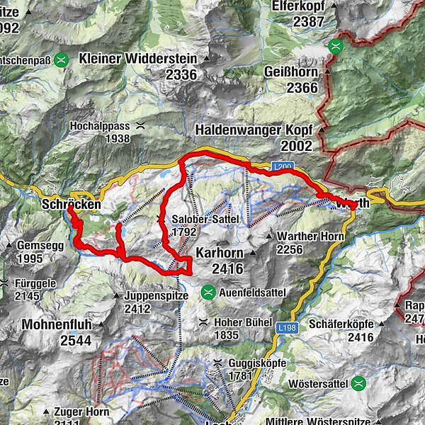
In Warth at the village square you start in the direction to the plot Wolfegg, from where you get on the way steeply up to the junction Alte Salzstraße. Via the Alte Salzstraße, a somewhat narrow path, you will reach the Jägeralpe and continue to the Hochtannbergpass. Now you should regain all your strength again, because from here it goes steadily upwards to the Salobersattel. From here, the path continues towards Auenfeld. The Auenfelder hut in the middle of this lush green floodplain invites you to linger and maybe there is just a fresh apple strudel? Strengthened, we continue on the broad path. Now it goes to the right on foot the narrow path up to the Körbersee. Back again it goes on the same way to the bikes. The wide gravel path leads you past the Alpe Batzen to the Alpmuseum Uf'm Tannberg. A short stop in the museum is really worthwhile, because there you can see the old craftsmanship of the mountain farmers. This path leads you further to the village of Schröcken.
The tour can of course also be started in Schröcken.
- Težavnost
-
srednja
- Ocenjevanje
-
- Pot
-
Warth (1.495 m)0,0 kmPfarrkirche St. Sebastian0,3 kmKitzeliftle0,6 kmWolfegg1,4 kmHolzbodenalpe2,7 kmJägeralpe3,6 kmSennkuchl3,6 kmHochkrumbach3,9 kmAlpekörb5,3 kmSB-Restaurant Salober5,5 kmS15,7 kmSalober-Sattel (1.792 m)7,0 kmAuenfelder Hütte8,0 kmMaterialseilbahn Körbersee16,1 kmSchröcken (1.269 m)16,3 kmTannberg16,3 km
- Najboljša sezona
-
janfebmaraprmajjunjulavgsepoktnovdec
- Najvišja točka
- 1.793 m
- Destinacija
-
Village square Warth/Village square Schröcken
- Profil nadmorske višine
-
-

-
AvtorTurneja Bike & Hike Körbersee uporablja outdooractive.com na spletni strani ..
GPS Downloads
Splošne informacije
Postanek za osvežitev
Notranji nasvet
Več izletov v regijah


