© Visit Éislek


- Kratek opis
-
From the leisurely afternoon round to the challenging hiking tour, everything is included in the Local Hiking Trails.
- Težavnost
-
srednja
- Ocenjevanje
-
- Pot
-
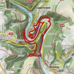
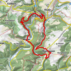
KehmenSaint-Aubin0,0 kmScheidel1,1 kmKehmen6,9 kmSaint-Aubin6,9 km
- Najboljša sezona
-
janfebmaraprmajjunjulavgsepoktnovdec
- Najvišja točka
- 489 m
- Destinacija
-
Kehmen
- Profil nadmorske višine
-
 © outdooractive.com

- Avtor
-
Turneja Local hiking trail BS 2 - Kehmen uporablja outdooractive.com na spletni strani ..
GPS Downloads


Splošne informacije
Obetavno
Več izletov v regijah
-
Guttland
412
-
Bourscheid
163